Mammoth in Yellowstone National Park in Park County, Wyoming — The American West (Mountains)
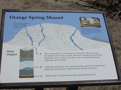
Orange Spring Mound
Photographed by Bill Coughlin, July 29, 2015
1. Orange Spring Mound Marker
Deep Origins
1. Yellowstone’s volcano heats water deep underground.
2. Under great pressure, the water percolates upward through buried limestone, dissolving a mineral called calcium carbonate.
3. Above ground, the water begins to cool and evaporate. Gasses are released and water pressure decreases. Orange Spring Mound gradually grows as the water flows over it, depositing calcium carbonate, or travertine.
Hot water flows over the mound after bubbling through several vents along the top.
Heat-dwelling bacteria and algae grow abundantly in Orange Spring Mound’s water, creating tapestries of “living color.”
Erected by National Park Service.
Topics. This historical marker is listed in this topic list: Natural Features.
Location. 44° 57.974′ N, 110° 42.894′ W. Marker is in Yellowstone National Park, Wyoming, in Park County. It is in Mammoth. It is on Upper Terrace Loop Drive, on the left when traveling west. Touch for map. Marker is in this post office area: Yellowstone National Park WY 82190, United States of America. Touch for directions.

Regionally, this marker
this page online
Other nearby markers. At least 8 other markers are within one mile of this marker, measured as the crow flies: Fort Yellowstone (approx. 0.4 miles away); A Changing Landscape (approx. 0.4 miles away); Guard Duty (approx. 0.9 miles away); a different marker also named A Sense of Community (approx. 0.9 miles away); Yellowstone National Park Chapel (approx. 0.9 miles away); Crime in Wonderland (approx. one mile away); Life in the Fort (approx. one mile away); The Parade Ground (approx. one mile away). Touch for a list and map of all markers in Yellowstone National Park.
Other markers no longer nearby. A Sense of Community (was approx. 0.9 miles away but has been permanently removed); At Guard (was approx. 0.9 miles away but has been permanently removed); A Most Fortunate Thing... (was approx. one mile away but has been permanently removed); The Drill Field (was approx. one
Photographed by Bill Coughlin, July 29, 2015
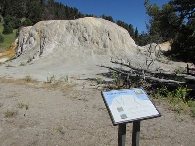
2. Orange Spring Mound Marker
Photographed by Bill Coughlin, July 29, 2015
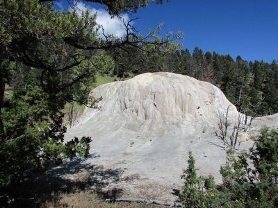
3. Orange Spring Mound
Credits. This page was last revised on February 16, 2023. It was originally submitted on September 10, 2015, by Bill Coughlin of Woodland Park, New Jersey. This page has been viewed 535 times since then and 26 times this year. Photos: 1, 2, 3. submitted on September 10, 2015, by Bill Coughlin of Woodland Park, New Jersey.
