
Tonopah in Nye County, Nevada — The American Mountains (Southwest)
WM. "Billy" Marsh
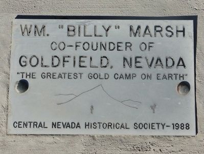
Photographed by Trev Meed, circa 2014
1. WM. "Billy" Marsh Marker
Co-Founder of Goldfield, Nevada
"The Greatest Gold Camp On Earth"
Erected 1988 by Central Nevada Historical Society.
Topics. This historical marker is listed in these topic lists: Cemeteries & Burial Sites • Settlements & Settlers.
Location. 38° 4.579′ N, 117° 14.947′ W. Marker is in Tonopah, Nevada, in Nye County. It can be reached from U.S. 95, on the left when traveling west. Located in the cemetery. Touch for map. Marker is in this post office area: Tonopah NV 89049, United States of America. Touch for directions.

Regionally, this marker is in the Mojave Desert and in Central Nevada. It is also in the American Southwest and in the Mountain West. Globally, it is in North America, the Western Hemisphere, the Western World, and the Anglosphere. Historically, it finds itself in what was once New Spain and also Mexico’s Alta California.
Other nearby markers. At least 8 other markers are within 2 miles of this marker, measured as the crow flies: Harry Stimler (here, next to this marker); First Tonopah Cemetery (approx. 0.7 miles away); Jim and Belle Butler
this page online
Credits. This page was last revised on May 10, 2026. It was originally submitted on October 12, 2015, by Trev Meed of Round Mountain, Nevada. This page has been viewed 360 times since then and 18 times this year. Photo 1. submitted on October 12, 2015, by Trev Meed of Round Mountain, Nevada. • Syd Whittle was the editor who published this page.
Editor’s want-list for this marker. PLEASE PROVIDE A WIDE VIEW PHOTO OF THE MARKER AND ITS SURROUNDINGS SHOWING ITS LOCATION IN CONTEXT. • • Can you help?
