Laramie in Albany County, Wyoming — The American West (Mountains)
The Overland Trail
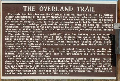
The route that later became the Overland Trail was followed in 1825 by William Ashley and members of the Rocky Mountain Fur Company, who entered the Laramie Valley from the south, forded the Medicine Bow River near Elk Mountain, and crossed the divide at Bridger's Pass. In 1843, an exploration party led by Captain John C. Fremont followed Ashley's path and determined it could be used for westward emigration. The portion of the route known as the Cherokee Trail was defined in 1849 when a group of Cherokee Indians bound for the California gold fields crossed southern Wyoming on their way west.
The route did not see heavy use until 1862, when Ben Holladay, who had recently acquired a contract to carry the U.S. mail, relocated the course of his Overland Stage Company to the south to avoid Indian attacks occurring along the Oregon Trail in central Wyoming. For several years, Holladay's Concord stages, heavily loaded with U.S. mail, carried passengers and other cargo along the Overland Trail through southern Wyoming.
From 1862 to 1868, the trail was the principal transportation corridor for thousands of emigrants moving west. Increased emigration led to clashes with Indians. Additional military forts, such as Fort Sanders and Fort Steele, were constructed to provide protection.
When construction began on the Transcontinental Railroad, Holladay realized demand for stagecoach travel would soon diminish. In 1866, he sold out to the Wells Fargo Stagecoach Line, which carried passengers and mail along the trail of another two and a half years. With the completion of the Transcontinental Railroad in 1869, Wells Fargo terminated its service along the route. Although railroad travel made the journey west quicker and easier than before, the Overland Trail continued to be used by emigrants until the turn of the century.
Erected by Wyoming Archives and Historical Department.
Topics and series. This historical marker is listed in this topic list: Roads & Vehicles. In addition, it is included in the Overland Trail series list.
Location. 41° 18.684′ N, 105° 48.078′ W. Marker is in Laramie, Wyoming, in Albany County. Marker is on Snowy Range Road (State Highway 130) near Cactus Hill Road, on the right when traveling west. Touch for map. Marker is at or near this postal address: 3184 Snowy Range Road, Laramie WY 82070, United States of America. Touch for directions.
Other nearby markers. At least 8 other markers are within 10 miles of this marker, measured as the crow flies. Bath Ranch (approx. 5.9 miles away); Old Overland Trail (approx. 6.3 miles away); Big Laramie Stage Station (approx. 6.6 miles away); Excavation Site: New Boiler Plant and Smoke Stack
(approx. 10 miles away); Excavation Site: Blacksmith Shop, Candle Shop, and Outhouse (approx. 10 miles away); Excavation Site: Old Kitchen and Bakery Ovens (approx. 10 miles away); Excavation Site: Basement Entrance to the Warden's House (approx. 10 miles away); Excavation Site: Ice House (approx. 10 miles away). Touch for a list and map of all markers in Laramie.
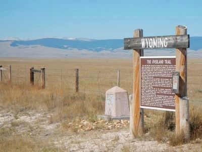
More about this marker. This marker is at a turnout on the north side of Wyoming Highway 130, approximately 10 miles west of the intersection with Wyoming Highway 230.
Also see . . . Overland Trail. Wikipedia entry (Submitted on November 19, 2022, by Larry Gertner of New York, New York.)
Photographed By Barry Swackhamer, September 8, 2015
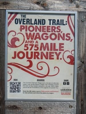
4. The Overland Trail (attached to The Overland Trail marker)
The Overland Trail: Pioneers, Wagons, and a 575 Mile Journey. Discover. The Overland Trail and Stagecoach Line was an alternate wagon route of the famous Oregon Trail. Pioneers crossed this area as they headed westward in the late 1800's. Make sure to see all 15 locations on the Legends of Laramie Tour.
Scan the QR code or go to the VisitLaramie.org/Overland to view photos and travel the plains by wagon.
Scan the QR code or go to the VisitLaramie.org/Overland to view photos and travel the plains by wagon.
Credits. This page was last revised on November 19, 2022. It was originally submitted on October 14, 2015, by Barry Swackhamer of Brentwood, California. This page has been viewed 1,193 times since then and 90 times this year. Photos: 1, 2, 3, 4. submitted on October 14, 2015, by Barry Swackhamer of Brentwood, California. 5. submitted on June 21, 2016, by Barry Swackhamer of Brentwood, California.
