Kingston, Ontario — Central Canada (North America)
Sir John A. Macdonald
(1815-1891)
Photographed by Kevin Craft, October 14, 2015
1. Sir John A. Macdonald Marker
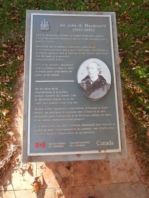
John A. Macdonald, a father of Confederation and Canada's first prime minister, dominated the life of the new nation for a quarter century.
Macdonald was a visionary statesman, a determined Conservative partisan, and a much-loved leader. His policies of westward expansion and of railways to the Atlantic and Pacific laid the basis of a successful transcontinental nation.
Still prime minister, Macdonald died in Ottawa on June 6, 1891. A simple stone cross marks his grave, as he wished.
Erected 1938 by Government of Canada.
Topics and series. This historical marker is listed in this topic list: Government & Politics. In addition, it is included in the Canada, Historic Sites and Monuments Board series list. A significant historical date for this entry is June 6, 1891.
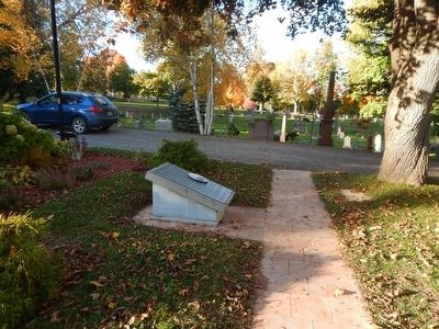
Location. 44° 15.732′ N, 76° 32.507′ W. Marker is in Kingston, Ontario. It can be reached from Beech Avenue. Marker is located next to Sir John A. Macdonald's burial site in the Cataraqui Cemetery. Upon entering the cemetery, follow the signs to the burial site and marker. Touch for map. Marker is at or near this postal address: 927 Purdy Mill Road, Kingston ON K7M 3N1,
this page online

Regionally, this marker is in Eastern Ontario and specifically in Southeastern Ontario. It is also in Central Canada. Globally, it is in North America, on the Great Lakes, in the Western Hemisphere, in the Western World, and in the Anglosphere. Historically, it finds itself in what was once a British colony, the Viceroyalty of New France, the Haudenosaunee (Iroquois) Confederacy, and Rupert’s Land.
Other nearby markers. At least 8 other markers are within 6 kilometers of this marker, measured as the crow flies: Roselawn / La Maison Roselawn (approx. 4.8 kilometers away); Donald Gordon Centre / Le Centre Donald Gordon (approx. 4.8 kilometers away); Kingston Penitentiary / Le Penitencier de Kingston (approx. 5.2 kilometers away); 1976 Olympic Cairn (approx. 5.2 kilometers away); The Coach House / La Remise (approx. 5.3 kilometers away); Bellevue House / Villa Bellevue (approx. 5.3 kilometers away); Queen's University's Royal Charter (approx. 5.4 kilometers away); Indigenous Pasts and Futures at Queen's/Passés et futurs autochtones à l'Université Queens (approx. 5.4 kilometers away). Touch for a list and map
Photographed by Kevin Craft, October 14, 2015
2. Wideview of Sir John A. Macdonald Marker
More about this marker. Kingston is independent from the surrounding Frontenac County.
Also see . . .
1. Parks Canada - Sir John A. Macdonald gravesite. (Submitted on October 27, 2015, by Kevin Craft of Bedford, Quebec.)
2. Wikipedia - Sir John A. Macdonald. (Submitted on October 27, 2015, by Kevin Craft of Bedford, Quebec.)

Internet Archive
3. Sir John A. Macdonald
Artist: Notman, Engraver: Hollyer, from Appleton's Cyclopædia of American Biography, 1889, Vol. 4, page 103.

Photographed by Kevin Craft, October 14, 2015
4. Sir John A. Macdonald tombstone and Marker
Sir John Alexander Macdonald 1815-1891
A delegate to the Intercolonial Conferences of 1864–1867 at which the basis was laid for the federal union of the British North American Provinces in a new nation.
The grave is marked and maintained in perpetuity by the Government of Canada.
Credits. This page was last revised on March 27, 2024. It was originally submitted on October 27, 2015, by Kevin Craft of Bedford, Quebec. This page has been viewed 519 times since then and 43 times this year. Photos: 1, 2. submitted on October 27, 2015, by Kevin Craft of Bedford, Quebec. 3. submitted on December 13, 2020, by Allen C. Browne of Silver Spring, Maryland. 4. submitted on October 27, 2015, by Kevin Craft of Bedford, Quebec.
