Near Oakfield in Worth County, Georgia — The American South (South Atlantic)
Battle of the Blankets
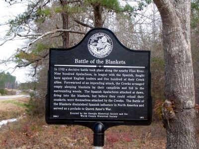
Photographed by David Seibert, February 9, 2005
1. Battle of the Blankets Marker
Erected 2004 by Georgia Historical Society and the Worth County Historical Society. (Marker Number 159-1.)
Topics and series. This historical marker is listed in these topic lists: Indigenous Peoples and Communities • Wars, US Indian. In addition, it is included in the Georgia Historical Society series list. A significant historical year for this entry is 1702.
Location. 31° 47.863′ N, 83° 57.447′ W. Marker is near Oakfield, Georgia, in Worth County. It is at the intersection of Georgia-Florida Parkway (State Highway 300) and
this page online

Regionally, this marker is in Georgia’s Coastal Plain. It is also in the American South and specifically in the Deep South. Globally, it is in North America, the Western Hemisphere, the Western World, and the Anglosphere. Historically, it finds itself in what was once the territory of the Mississippian Culture, one of the original Thirteen Colonies, one of the Confederate States of America, and the Antebellum South.
Other nearby markers. At least 8 other markers are within 12 miles of this marker, measured as the crow flies: Fort Early (approx. 4.6 miles away); The Southern People (approx. 4.7 miles away); Chehaw (approx. 10.2 miles away); Georgia Veterans Memorial State Park (approx. 11.1 miles away); Veterans of Foreign Wars Group Camp (approx. 11.1 miles away); Republic F-84F Thunderstreak (approx. 11.4 miles away); 114th Aviation Company (approx. 11½ miles away); Bell UH-ID Iroquois “Huey” (approx. 11½ miles away).
Another marker is no longer nearby. Fort Early (was approx. 5 miles away but has been confirmed missing).
Credits. This page was last revised on June 16, 2016. It was originally submitted on July 8, 2008, by David Seibert of Sandy Springs, Georgia. This page has been viewed 3,580 times since then and 74 times this year. Photo 1. submitted on July 8, 2008, by David Seibert of Sandy Springs, Georgia. • Kevin W. was the editor who published this page.
Editor’s want-list for this marker. A wide shot of the marker and its surroundings. • Can you help?
