Green River in Sweetwater County, Wyoming — The American West (Mountains)
Crossing and Cruising:
Navigating the River
Photographed by Barry Swackhamer, September 10, 2015
1. Crossing and Cruising Marker
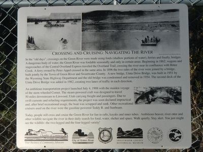
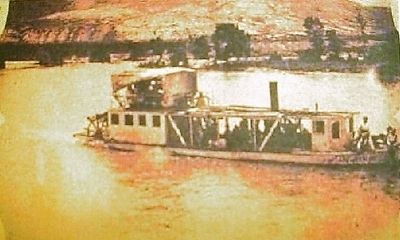
An ambitious transportation project launched July 4, 1908 with the maiden voyage of the stern-wheeled Comet. The steam-powered craft was designed to travel 50 miles downstream to Linwood carrying freight and passengers. Due to swift currents and refueling requirements, the project was soon declared impractical and
this page online
Today, people still cross and cruise the Green River for fun in rafts, kayaks and inner tubes. Ambitious beaver, river otter and other wildlife navigate the river in their daily search for food, water, shelter and space. Walk quietly, Stay alert. You just might see the wildlife - two-legged and the four-legged variety!
Erected by Green River Chamber of Commerce, City of Green River, Wyoming Game & Fish Department, Sweetwater County Historical Museum, Wildlife Heritage Foundation of Wyoming and Wyoming Governors's Big Game License Coalition.
Topics. This historical marker is listed in this topic list: Waterways & Vessels. A significant historical date for this entry is June 4, 1908.
Location. 41° 32.212′ N, 109° 28.851′ W. Marker is in Green River, Wyoming, in Sweetwater County. It is on West Flaming Gorge Way near Hillcrest Way, on the left when traveling north. Touch for map. Marker is at or near this postal address: 1155 West Flaming Gorge Way, Green River WY 82935, United
Photographed by Unknown, circa 1908
2. Crossing and Cruising: Marker

Regionally, this marker is in the Westward Expansion Trails Region. It is also in the American Mountain West. Globally, it is in North America, the Rocky Mountains, the Western Hemisphere, the Western World, and the Anglosphere. Historically, it finds itself in what was once Mexico’s Alta California.
Other nearby markers. At least 8 other markers are within walking distance of this marker: Construction and Cooling: (within shouting distance of this marker); The 24-Hour Town (within shouting distance of this marker); Green River: No Longer Wild, Forever Tamed (within shouting distance of this marker); Green River Brewery (approx. 0.8 miles away); Oregon Trail Memorial (approx. 0.9 miles away); John Wesley Powell (approx. 0.9 miles away); The Paddlewheeler Comet - 1908 (approx. one mile away); Sunbeam - 1908 (approx. one mile away). Touch for a list and map of all markers in Green River.
More about this marker. The markers is located at the Green River Visitors Center.
Photographed by Barry Swackhamer, September 10, 2015
3. Crossing and Cruising Marker
Credits. This page was last revised on June 16, 2016. It was originally submitted on October 28, 2015, by Barry Swackhamer of Brentwood, California. This page has been viewed 523 times since then and 26 times this year. Photos: 1, 2, 3. submitted on October 28, 2015, by Barry Swackhamer of Brentwood, California.
