Near Manila (Utah) in Sweetwater County, Wyoming — The American West (Mountains)
Linwood Bay
Linwood - The Town That Drowned
Photographed by Barry Swackhamer, September 10, 2015
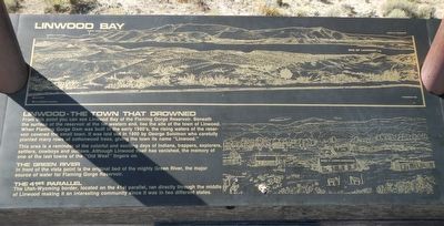
1. Linwood Bay Marker, center panel
From this point you can see Linwood Bay of the Flaming Gorge Reservoir. Beneath the surface of the reservoir at the far western end, lies the site of the town of Linwood. When Flaming Gorge Dam was built in the early 1960's, the rising water of the reservoir covered the small town. It was laid out in 1900 by George Solomon who carefully planted many rows of cottonwood trees, giving the town its name "Linwood."
This area is a reminder of the colorful and exciting days of Indians, trappers, explorers, settlers, cowboys and outlaws. Although Linwood itself has vanished, the memory of one of the last towns of the "Old West" lingers on.
The Green River
In front of the vista point is the original bed of the mighty Green River, the major source of water for Flaming Gorge Reservoir.
The 41st Parallel
The Utah-Wyoming border, located on the 41st parallel, ran directly through the middle of Linwood making it an interesting community since it was in two different states.
Left panel:
The Uinta Mountains
The only major mountain range in the Western Hemisphere to
this page online
Flaming Gorge
Named by John Wesley Powell in 1869, Flaming Gorge is probably the most interesting and dramatic geological feature in the area. It is located in front of you to the left at the end of the range of mountains.
Different Geological Formations It's interesting to note the different geological formations of the area.
Right panel:
Henry's Fork
Named for Maj. Andrew Henry, the fork was an early camping and gathering place for trappers, traders and explorers. Gen. William Ashley originated the "rendezvous" system for fur trade here. Early in July, 1825, 120 trappers and mountain men arrived at the first rendezvous site, approximately 15 miles up Henry's Fork, to trade furs and supplies.
Uncle Jack Robinson's Cabin
The first permanent settler in the area was John Robinson, known as "Uncle Jack Robinson," who built a cabin on Lower Henry's Fork in 1834-35. The cabin was moved to a location near Flaming Gorge Recreation Area.
Other Points
Also located in the area was Jim Baker's Trading Post, established in 1839. Soon

Photographed by Barry Swackhamer, September 10, 2015
2. Linwood Bay Marker, left panel
Captions: (left) The rocks generally lie flat and are light colored and soft. Firehole.; (right) In Utah, the rock are more colorful and have been bent and forced upward by tremendous earth pressure. Sheep Creek.
Two Canals
The Lucerne Valley Land and Water Company Canal and the People's Canal were completed near the turn of the century. The canals brought irrigation to settlers in the dry valleys.
Bob Swift's Bucket of Blood Saloon
Located a few hundred yards from Uncle Jack's cabin, the "wild and wooly" saloon was frequented by such outlaws as Butch Cassidy and the Sundance Kid, the McCarty boys, and the Curry gang.
The Linwood School or "Stateline School"
The school, which was constructed in the fall of 1904, has the distinction of being the only school in the country to be run by two different state school boards - the north half of the school was in Wyoming and the south half was in Utah. The school is now used as a grainary one mile north of its original location.
Octagonal Dancehall
The dance hall was a beautiful and magnificent structure and had the first real hardwood floor in the region.
Erected by U.S. Forest Service, Daggett County Historical

Photographed by Barry Swackhamer, September 10, 2015
3. Linwood Bay Marker, right panel
Topics. This historical marker is listed in these topic lists: Man-Made Features • Settlements & Settlers.
Location. 41° 0.126′ N, 109° 37.71′ W. Marker is near Manila (Utah), Wyoming, in Sweetwater County. It is on Lucerne Valley Recreation Road (County Route 147) near Wyoming Highway 530, on the right when traveling east. Touch for map. Marker is in this post office area: Manila UT 84046, United States of America. Touch for directions.

Regionally, this marker is in the Westward Expansion Trails Region. It is also in the American Mountain West. Globally, it is in North America, the Rocky Mountains, the Western Hemisphere, the Western World, and the Anglosphere. Historically, it finds itself in what was once Mexico’s Alta California.
Other nearby markers. At least one other marker is within 13 miles of this marker, measured as the crow flies: Flaming Gorge Dam: The Good, the Bad & the Beautiful (approx. 12.3 miles away in Utah).
More about this marker. The Linwood Bay overlook is about 1 1/2

Photographed by Barry Swackhamer, September 10, 2015
4. Linwood Bay Marker
Also see . . . History of Flaming Gorge, Utah - OnlineUtah. bout sixty river miles below the town of Green River, Wyoming, the Green entered a series of canyons that were of rare beauty, and yet were largely unknown except to Indians, outlaws, and river runners... First was Flaming Gorge, named by Powell for the brilliant, flaming red of its rocks. Here was supposedly the site of the legendary "Green River Suck," said by early river runners to be a cataract that continued for "six or eight miles, making a sheer descent... (Submitted on October 30, 2015, by Barry Swackhamer of Brentwood, California.)

Photographed by Barry Swackhamer, September 10, 2015
5. Linwood Bay from the overlook
Credits. This page was last revised on December 6, 2020. It was originally submitted on October 30, 2015, by Barry Swackhamer of Brentwood, California. This page has been viewed 1,932 times since then and 221 times this year. Photos: 1, 2, 3, 4, 5. submitted on October 30, 2015, by Barry Swackhamer of Brentwood, California.
