Davis in Yolo County, California — The American West (Pacific Coastal)
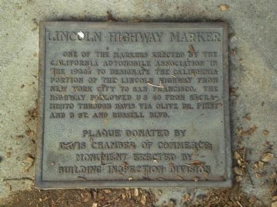
Lincoln Highway Marker
Plaque donated by Davis Chamber of Commerce. Monument erected by Building Inspection Division.
Erected by City of Davis Chamber of Commerce and Building Inspection Division.
Topics and series. This historical marker is listed in this topic list: Roads & Vehicles. In addition, it is included in the Lincoln Highway series list.
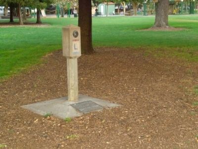
Location. 38° 32.784′ N, 121° 44.719′ W. Marker is in Davis, California, in Yolo County. Marker is at the intersection of Russell Boulevard and B Street, on the left when traveling west on Russell Boulevard. The marker/monument are in a grove of trees at the NW corner of Central Park. Touch for map. Marker is in this post office area: Davis CA 95616, United States of America. Touch for directions.
Other nearby markers. At least 8 other markers are within walking distance of this marker. Davis Library Building (within shouting distance of this marker); Old Davis High School (about 400 feet away, measured in a direct line); First Bicycle Lanes in Davis (approx. 0.2 miles away); The Bentley House (approx. ¼ mile away); Richard E. Lyng (approx. 0.3 miles away); Historic City Hall (approx. 0.3 miles away); Dresbach-Hunt-Boyer Mansion (approx. 0.3 miles away); Davis Cooperative Centennial, 1887-1987 (approx. 0.3 miles away). Touch for a list and map of all markers in Davis.
Regarding Lincoln Highway Marker. The following is adapted from the Federal Highway Administration's web page on the history of the Lincoln Highway. The reader is urged to consult the full text for a better understanding and more details.
"On July 1, 1913, a group of automobile enthusiasts and industry officials established the Lincoln Highway Association (LHA) "to procure the establishment of a continuous improved highway from the Atlantic to the Pacific, open to lawful traffic of all description without toll charges." In its time, the Lincoln Highway would become the Nation's premier highway, as well known as U.S. 66 was to be in its day and as well known as I-80 and I-95 are today.
The Lincoln Highway also played an important role in the evolution of highways leading up to the Dwight D. Eisenhower System of Interstate and Defense Highways. This role
is illustrated by the LHA's twin goals. One goal was to build a "Coast-to-Coast Rock Highway" from Times Square in New York City to Lincoln Park in San Francisco. The second goal was to make the Lincoln Highway an object lesson that would, in the words of its creator, Carl G. Fisher, "stimulate as nothing else could the building of enduring highways everywhere that will not only be a credit to the American people but that will also mean much to American agriculture and American commerce."
The LHA announced the route on September 14, 1913 . That initial line was 3,389 miles long. Less than half of it, 1,598 miles, was improved. (Eventually, as segments of the route were improved, the length shrunk to about 3,140 miles).
Some segments of the Lincoln Highway followed historic roads.
In the East, the Lincoln Highway incorporated a road laid out by Dutch colonists of New Jersey before 1675.
The route in Pennsylvania followed the 62-mile Philadelphia to Lancaster Pike, the first extensive turnpike in the United States (completed in 1796), and a British military trail built in 1758 by General John Forbes of England from Chambersburg to Pittsburgh during the French and Indian War. It was later known as the Pittsburgh Road and the Conestoga Road.
A section in Ohio followed an ancient Indian trail known as the Ridge Road.
In the West, the Lincoln
Highway used sections of the Mormon Trail (the route along which Brigham Young led his Mormon followers to Utah), as well as the route of the Overland Stage Line and the Pony Express.
Entering California, a motorist on the Lincoln Highway crossed the Sierra Nevada through Donner Pass, named after the Donner Party, which became stranded after attempting to cross through the pass too late in the winter of 1846-1847, or could follow an alternate route that was once a pioneer stage coach route.
The LHA dedicated the route of the Lincoln Highway on October 31, 1913. Bonfires and fireworks marked ceremonies in hundreds of cities in the 13 States along the line. Concerts and parades took place. In at least two locations, the streets were swept and washed so dances could be held on the highway.
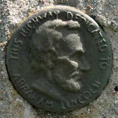
The Lincoln Highway was officially marked and dedicated to the memory of Abraham Lincoln on September 1, 1928. On that day, at 1:00 p.m., groups of Boy Scouts placed approximately 3,000 concrete markers at sites along the route. They were placed on the outer edge of the right-of-way at each important crossroad, at minor crossings, and at other intervals to assure each motorist that he was on the right road. The signs carried the Lincoln Highway insignia, a bronze medallion ("This Highway Dedicated to Abraham Lincoln") and a directional arrow.
Over the years, the Lincoln Highway became little more than a memory, with relics and reminders along the way:
Some segments of U.S. 30 still carry the name, as in Pennsylvania.
Roads in some cities, such as Ames, Iowa, are still known as "Lincoln Way."
A few of the 3,000 Boy Scout markers can still be found along the old route.
Near Elkhorn, Nebraska, a stretch of Lincoln Highway paved with brick has been preserved by a local historical group.
A bridge with railings spelling out "LINCOLN HIGHWAY" remained in use as part of Route E-66 in Tama County, Iowa.
Restaurants, motels, and gas stations in many locations still carry a Lincoln-related name.
In Wamsutter, Wyoming, on the Continental Divide along old U.S. 30, a monument was erected in 1938 to Henry B. Joy, President of the LHA during its early years. The inscription describes Joy as one "who saw realized the dream of a continuous improved highway from the Atlantic to the Pacific." Not far from the memorial, a motorist could see an abandoned stretch of the Lincoln Highway, weeds growing through the cracks in the pavement, along its modern reincarnation, I-80."
Also see . . . The Federal Highway Administration's Lincoln Highway History Web Page. (Submitted on July 10, 2008, by Andrew Ruppenstein of Lamorinda, California.)
Credits. This page was last revised on June 16, 2016. It was originally submitted on July 10, 2008, by Andrew Ruppenstein of Lamorinda, California. This page has been viewed 4,106 times since then and 39 times this year. Photos: 1, 2. submitted on July 10, 2008, by Andrew Ruppenstein of Lamorinda, California. 3. submitted on July 11, 2008, by Kevin W. of Stafford, Virginia. • Kevin W. was the editor who published this page.


