Lake Providence in East Carroll Parish, Louisiana — The American South (West South Central)
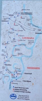
Grant's March Through Louisiana
Inscription.
Marker middle
Winter Quarters
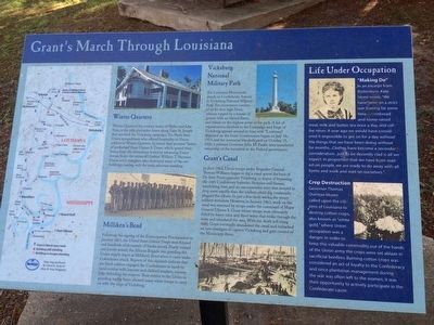
Winter Quarters, the country home of Haller and Julia Nutt, is the only plantation home along Lake Saint Joseph that survived the Vicksburg campaign. The Nutts were Union sympathizers who offered hospitality to Union soldiers at Winter Quarters. In return they received "letters of protection" from Ulysses S. Grant, which spared their home from the devastation levied by advancing Union troops under the orders of General William T. Sherman. Union army stragglers later destroyed many of the out-buildings, leaving only the main structure standing.
Milliken's Bend
Following the signing of the Emancipation Proclamation in January 1863, the United States Colored Troops were formed and hundreds of thousands of blacks served. Poorly trained and poorly armed, the African Brigade was guarding the Union supply depot at Milliken's Bend when it came under Confederate attack. Reports of this skirmish indicate that the black soldiers engaged the Confederates in hand-to-hand combat with bayonet and clubbed muskets, successfully defending the outpost. Their service to the Union in guarding supply bases allowed many white troops to carry on with the siege of Vicksburg.
Vicksburg National Military Park
The Louisiana Monument stands on Confederate Avenue in Vicksburg National Military Park. The monument consists of an 81-foot high Doric column topped by a brazier of granite with an eternal flame, and stands on the highest point in the park. A list of organizations involved in the Campaign and Siege of Vicksburg appears on its base with "Louisiana" displayed on the front. Construction begun on July 10, 1919, and the memorial was dedicated on October 18, 1920. Louisiana Governor John M. Parker later transferred ownership of the memorial to the Federal government.
Grant's Canal
In June 1862, Union troops under Brigadier General Thomas Williams began to dig a canal across the base of De Soto Point, opposite Vicksburg, in hopes of bypassing the city's Confederate batteries. Sickness and disease, unrelenting heat, and an uncooperative river that seemed to drop more rapidly than the soldiers could dig continually plagued the efforts. In just a few short weeks, the weary soldiers withdrew. However, in January 1863, work on the canal was resumed by troops under the command of Major General Ulysses S. Grant whose troops were ultimately foiled by heavy rains and flood waters that broke through the levee and inundated the area. With the death toll rising daily, Grant eventually abandoned the canal and embarked on new strategies to capture Vicksburg and gain control of the Mississippi River.
Marker right
Life Under Occupation
"Making Do"
In an excerpt from Brokenburn, Kate Stone wrote, "We have been on a strict war footing for some time — cornbread, and home-raised meal, milk and butter, tea once a day, and coffee never. A year ago we would have considered it impossible to get on for a day without the things that we have been doing without for months...Clothes have become a secondary consideration...just to be decently clad is all we expect. In proportion that we have been waited-on people, we are ready to do away with all the forms and work and wait on ourselves."
Crop Destruction
Governor Thomas Overton Moore called upon the citizens of Louisiana to destroy cotton crops, also known as "white gold," where Union occupation was a danger. In order to keep this valuable commodity out of the hands of the Union army the crops were set ablaze in sacrificial bonfires. Burning cotton crops was considered an act of loyalty to the Confederacy and since plantation management during the war was often left to the women, it was their opportunity to actively participate in the Confederate cause.
Topics. This historical marker is listed in these topic lists: African Americans •
War, US Civil • Waterways & Vessels. A significant historical month for this entry is January 1863.
Location. 32° 48.428′ N, 91° 10.466′ W. Marker is in Lake Providence, Louisiana, in East Carroll Parish. Marker can be reached from the intersection of Lake Street (U.S. 65) and Lake Street. Touch for map. Marker is at or near this postal address: 600 Lake Street, Lake Providence LA 71254, United States of America. Touch for directions.
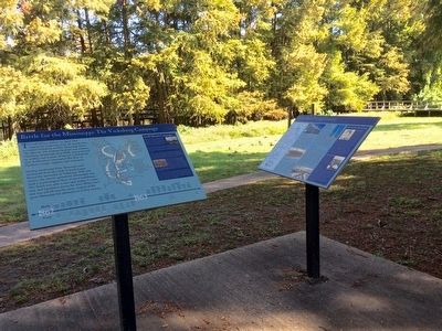
Other nearby markers. At least 8 other markers are within 3 miles of this marker, measured as the crow flies. Battle for the Mississippi: The Vicksburg Campaign (a few steps from this marker); Grant's Canal (within shouting distance of this marker); Soldiers' Rest (approx. half a mile away); Lake Providence Confederate Monument (approx. 0.6 miles away); Hood Home Plantation (approx. 2.1 miles away); Gin Office (approx. 2.1 miles away); The Barn (approx. 2.2 miles away); Farming By Hand (approx. 2.2 miles away). Touch for a list and map of all markers in Lake Providence.
More about this marker. This is a duplicate of marker #60239 located in Mound, LA at the I-20 Westbound Rest Area.
Credits. This page was last revised on February 21, 2022. It was originally submitted on November 8, 2015, by Mark Hilton of Montgomery, Alabama. This page has been viewed 614 times since then and 41 times this year. Photos: 1, 2, 3, 4. submitted on November 8, 2015, by Mark Hilton of Montgomery, Alabama.


