Near Breaks in Dickenson County, Virginia — The American South (Mid-Atlantic)
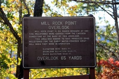
Mill Rock Point Overlook
Mill Rock Point is so named because at one time millstones were carved from layered sandstone at the base of this overlook.
This area was known to have produced good millstones for the early water-powered grist-mill when they were in operation.
Elevation here 1660 ft.
Overlook elevation 1620 ft.
River Elevation 1030 ft.
Overlook 65 yards.
Topics. This historical marker is listed in these topic lists: Industry & Commerce • Natural Features • Natural Resources.
Location. 37° 16.976′ N, 82° 17.319′ W. Marker is near Breaks, Virginia, in Dickenson County. Marker is on Virginia Route 80, one mile south of Breaks, on the right when traveling east. It is at a pull-off with parking. Touch for map. Marker is in this post office area: Breaks VA 24607, United States of America. Touch for directions.
Other nearby markers. At least 8 other markers are within 2 miles of this marker, measured as the crow flies. Mill Rock Point (a few steps from this marker); The Crooked Road (a few steps from this marker); Formation Of The Breaks (approx. 0.3 miles away); Salt Kettle (approx. half a mile away); Early Settlement (approx. half a mile away); The Name Breaks (approx. 0.8 miles away); Clinchfield Overlook (approx. 0.9 miles away); Known But to God (approx. 1.7 miles away in Kentucky). Touch for a list and map of all markers in Breaks.
Credits. This page was last revised on December 29, 2022. It was originally submitted on November 17, 2015, by J. J. Prats of Powell, Ohio. This page has been viewed 446 times since then and 20 times this year. Photos: 1, 2, 3. submitted on November 17, 2015, by J. J. Prats of Powell, Ohio.


