Centro Histórico in Ciudad de México, Mexico — The Valley of Mexico (The Central Highlands)
Alfredo Robles Domínguez
Photographed by J. Makali Bruton, October 31, 2015
1. Alfredo Robles Domínguez Marker

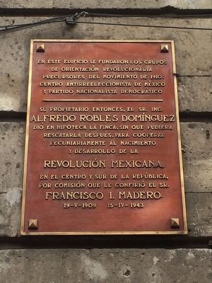
En este edificio se fundaron los grupos
de orientación revolucionaria
precursores del movimiento de 1910:
Centro antirreeleccionista de México
y Partido Nacionalista Demócratico
Su propietario entonces, el Sr. Ing.
Alfredo Robles Domínguez
dió en hipoteca la finca, sin que pudiera
rescatarla después, para cooperar
pecuniariamente al nacimiento
y desarrollo de la
Revolución Mexicana,
En el centro y sur de la República,
por comisión que le confirió el Sr.
Francisco I. Madero.
19-V-1909 15-IV-1943
In this building, the first groups with a revolutionary orientation and considered to be the precursors of the Movement of 1910 were founded:
The Anti-Reelection Center and the Nationalist Democratic Party
Its owner at that time,
Alfredo Robles Domínguez
mortgaged the property and was not able to ever recover it later, as his way of cooperating financially with the birth and development of the Mexican Revolution
in the center and south of the Republic under a commission that was given to him by Francisco I. Madero.
May 19, 1909 - April 15, 1943
Topics. This memorial is listed in these topic lists: Government & Politics
this page online
Location. 19° 26.122′ N, 99° 8.11′ W. Memorial is in Ciudad de México. It is in Centro Histórico. It is on Calle Tacuba, on the right when traveling west. Touch for map. Memorial is in this post office area: Ciudad de México 06000, Mexico. Touch for directions.

Regionally, this memorial is in Central Mexico and specifically in Mexico City Metropolitan Area. Globally, it is in North America, specifically in Mesoamerica, on the Ring of Fire, and in the Western Hemisphere. Historically, it finds itself in what was once New Spain, a Spanish colony, and the Aztec Empire.
Other nearby markers. At least 8 other markers are within walking distance of this marker: Juan de la Sala (within shouting distance of this marker); Francisco González Bocanegro (within shouting distance of this marker); Gonzalo A. Esteva (within shouting distance of this marker); Hernán Cortés' Residences (within shouting distance of this marker); House of the Counts of Heras y Soto (about 120 meters away, measured in a direct line); Juan Xuárez (about 120 meters away); Manuel Payno (about 120
Photographed by J. Makali Bruton, October 31, 2015
2. Alfredo Robles Domínguez Marker
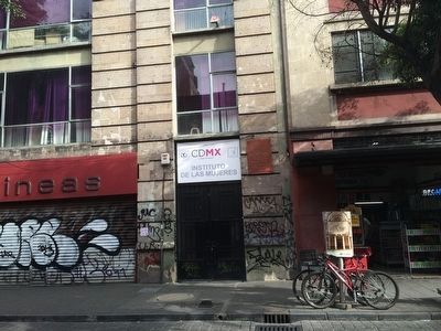
The building is now the Women's Institute (Instituto de las Mujeres).
Credits. This page was last revised on March 4, 2025. It was originally submitted on November 21, 2015, by J. Makali Bruton of Washington, District of Columbia. This page has been viewed 1,043 times since then and 20 times this year. Photos: 1, 2. submitted on November 21, 2015, by J. Makali Bruton of Washington, District of Columbia.
