Killen in Lauderdale County, Alabama — The American South (East South Central)
Mitchell Town Community
Photographed by Sandra Hughes, September 12, 2015
1. Mitchell Town Community Marker (side 1)
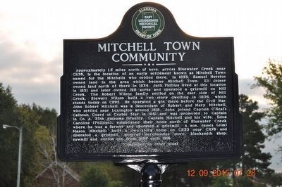
Approximately 1.5 miles north of here, across Bluewater Creek near CR76, is the location of an early settlement known as Mitchell Town named for the Mitchells who settled there. In 1833, Samuel Herston owned land in the area which became Mitchell Town. Eli Joiner owned land north of there in 1834. Jack Phillips lived at this location in 1831, and later owned 198 acres and operated a gristmill on Mill Creek. The Robert Wilson family settled on the east side of Mill Creek. Stewart Wilson built a two~story dwelling in 1836, which stands today on CR92. He operated a gin there before the Civil War. John Robert Mitchell was a descendant of Robert and Mary Mitchell, who settled near Lexington around 1818. John joined Captain O’Neal’s Calhoun Guard at Center Star in 1861 and was promoted to Captain in Co. A. 35th Alabama Infantry. Captain Mitchell and his wife, Edna Caroline (Phillips), established their home north of Bluewater Creek were he was a farmer and operated a gristmill. A son, James (Jim) Mason Mitchell, built a two story home on CR33 near CR76 and operated a gristmill, general merchandise store, blacksmith
this page online
Photographed by Sandra Hughes, September 12, 2015
2. Mitchell Town Community Marker (side 2)
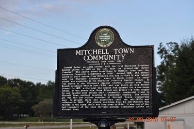
Erected 2014 by East Lauderdale Historical Society.
Topics. This historical marker is listed in these topic lists: Settlements & Settlers • War, US Civil. A significant historical year for this entry is 1833.
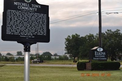
Location. 34° 51.607′ N, 87° 26.391′ W. Marker is in Killen, Alabama, in Lauderdale County. It is at the intersection of Lee Highway (U.S. 72) and County Route 33, on the right when traveling west on Lee Highway. Marker is located at the Elkins East Chapel parking lot. Touch for map. Marker is at or near this postal address: 7435 US-72, Killen AL 35645, United States of America. Touch for directions.

Regionally, this marker is in North Alabama and in the Shoals. It is also in the American South, specifically in the Deep South, in Appalachia, and specifically in Southern Appalachia. Globally, it is in North America, a Gulf of Mexico state, the Western Hemisphere, the Western World, and the Anglosphere. Historically, it finds itself
Photographed by Sandra Hughes, September 12, 2015
3. Mitchell Town Community Marker
Other nearby markers. At least 8 other markers are within 3 miles of this marker, measured as the crow flies: Jesse James Gang Canal Payroll Robbery / Trial of Frank James (approx. 0.3 miles away); Center (Centre) Star (approx. 0.9 miles away); Earliest Methodist Congregation in Lauderdale County, Alabama (approx. 1.1 miles away); Gabriel Butler Cemetery (approx. 1½ miles away); Gabriel “Old Gabe” Butler (approx. 1½ miles away); Cherokee Chief Doublehead's Village Around 1800 (approx. 1.6 miles away); Daniel White (approx. 1.7 miles away); Elgin/Elgin Crossroads (approx. 2.8 miles away). Touch for a list and map of all markers in Killen.
Credits. This page was last revised on June 16, 2016. It was originally submitted on November 22, 2015, by Sandra Hughes Tidwell of Killen, Alabama, USA. This page has been viewed 2,309 times since then and 138 times this year. Photos: 1, 2, 3. submitted on November 22, 2015, by Sandra Hughes Tidwell of Killen, Alabama, USA. • Bernard Fisher was the editor who published this page.
