Colonia Bosque de Chapultepec I Sección in Ciudad de México, Mexico — The Valley of Mexico (The Central Highlands)
Chapultepec Hill
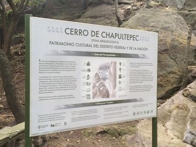
Cerro de Chapultepec
Patrimonio Cultural del Distrito Federal y de la Nación
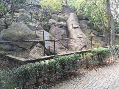
Los grabados han sufrido diversas destrucciones a través del tiempo. Aunque una de las más graves fue la realizada por orden del obispo fray Juan de Zumárraga en 1539, también se tiene registro de la ocurrida con Juan Eugenio Santelizes en 1775. El deterioro continuó hasta 1923, cuando el sitio se delimitó con un barandal, y para 1945 quedó dentro del área asignada al Museo Nacional de Historia.
Entre lo que aún puede verse destacan símbolos calendáricos como Ome actl (dos caña), Xiuhuitzolli (diadema de turquesa), Atl-tlachinolli (agua-fuego), Ce cipatli (uno cocodrilo), Ce quiahuitl (uno lluvia) y Ce tecpal (uno pedernal).
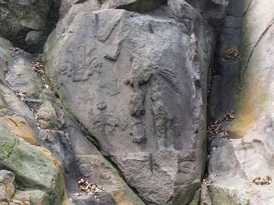
También está el retrato de un gobernante que suponemos es Moctezuma II, quien lleva unas cintas que sujetaban el quetzalalpitoa consistente en dos borlas de plumas ricas, guarnecidas de oro que los reyes usaban atadas de los cabellos a la coronilla y que colgaban hasta las sienes. Se observan las piernas y los pies; el brazo derecho encogido muestra la sonaja de hueso llamada amichicahuaz.
El cerro de Chapultepec es un testigo de diversos acontecimientos históricos. En él confluyen elementos de diferentes épocas, como estas rocas, las cuales deben despertar nuestro respeto y admiración.
Pie de foto:
Reconstrucción hipotética basada en antiguos dibujos, fotografías, y distantas investigaciones.
Distinguido visitante:
Siguen varias instrucciones básicas de cuidar y no dañar los vestigios arqueológicos.
Cultural Heritage of the Federal District and the Nation
The Chapultepec Hill was an object of reverence in pre-Hispanic times; portraits of rulers were carved here. The first to command that his image be carved here was Moctezuma Ilhuicamina, followed by Axayácatl and Moctezuma II; however, only vestiges of the last ruler's image remain.
The images have suffered damage over time. Although one of the most serious examples of destruction was made by order of Bishop Juan de Zumárraga in 1539, there are also records of damage done by Juan Eugenio Santelizes in 1775. The decline of the site continued until 1923, when the site was delimited with a protective fence, and by 1945 it was assigned as an official area within the National Museum of History. Some of the images that can still be vaguely seen are calendrical symbols like Ome actl (two canes), Xiuhuitzolli (turquoise headband), Atl-tlachinolli (water- fire),Ce cipatli (one crocodile), Ce Quiahuitl (one rain) and Ce tecpal (one flint).
There is also a portrait of a ruler who we assume is Moctezuma II. He has ribbons that hold a quetzalalpitoa consisting of two rich, gold-trimmed feather tassels that kings wore tied to their hair and that hung down over their forehead. The legs and feet of the image can be seen; the shrunken right arm shows a rattle made of bone called an amichicahuaz .
The Chapultepec Hill has been witness to many historical events. It combines elements from different eras, like these rocks, which should arouse our respect and admiration.
Caption:
Hypothetical reconstruction based on period drawings, photographs and various other research.
Distinguished visitor:
Various basic instructions on preserving and not damaging the archaeological remains.
Copyright 2015 HMdb.org, all rights reserved for the
translation unless otherwise noted.
Erected by Instituto Nacional de Antropología e Historia y Consejo Nacional para la Cultura y las Artes.
Topics. This historical marker is listed in this topic list: Man-Made Features. A significant historical year for this entry is 1539.
Location. 19° 25.245′ N, 99° 10.836′ W. Marker is in Ciudad de México. It is in Colonia Bosque de Chapultepec I Sección. Marker can be reached from Calle del Rey. The marker is at the eastern base of the Chapultepec Castle hill, on a walkway that goes around the southern half of the hill. Touch for map. Marker is in this post office area: Ciudad de México 11100, Mexico. Touch for directions.
Other nearby markers. At least 8 other markers are within walking distance of this marker. Juan Escutia, Child Hero of Mexico (within shouting distance of this marker); Monument to the Children Heroes of 1847 (within shouting distance of this marker); Obelisk of the Children Heroes (within shouting distance of this marker); Vicente Suárez, Child Hero of Mexico (within shouting distance of this marker); The Heroic Cadets (within shouting distance of this marker); The Castle Garden (within shouting distance of this marker); Sounds in the Distance (within shouting distance of this marker); Museum of National History (about 90 meters away, measured in a direct line). Touch for a list and map of all markers in Ciudad de México.
Credits. This page was last revised on April 17, 2020. It was originally submitted on December 5, 2015, by J. Makali Bruton of Accra, Ghana. This page has been viewed 432 times since then and 10 times this year. Photos: 1. submitted on December 5, 2015, by J. Makali Bruton of Accra, Ghana. 2, 3. submitted on December 6, 2015, by J. Makali Bruton of Accra, Ghana.


