Near Yuma in Yuma County, Arizona — The American Mountains (Southwest)
Flora Temple Mine
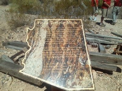
Photographed by Keith B. Dodds, April 18, 2015
1. Flora Temple Mine Marker
The ore retrieved from the mine was Silver-Galena which mainly consisted of silver and lead. In 1979 when the prices of silver dropped, mining of Silver-Galena ore was no longer profitable. Maybe someday the Flora Temple Mine will flourish again.
Erected 2015 by E Clampus Vitus.
Topics and series. This historical marker is listed in these topic lists: Industry & Commerce • Waterways & Vessels. In addition, it is included in the E Clampus Vitus series list. A significant historical date for this entry is April 18, 2015.
Location. 33° 2.786′ N, 114° 10.68′ W. Marker is near Yuma, Arizona, in Yuma County. It is on U.S. 95. 33° 2.766′ N, 114° 10.668′ W. Marker is near Yuma, Arizona,
this page online

Regionally, this marker is in Arizona’s Colorado River Valley, in the Sonoran Desert, and in the Yuma Area. It is also in the American Borderlands and in the Southwest. Globally, it is in North America, the Western Hemisphere, the Western World, and the Anglosphere. Historically, it finds itself in what was once New Spain and also the Gadsden Purchase.
Other nearby markers. At least one other marker is within walking distance of this marker: Castle Dome Mining District (within shouting distance of this marker).
Credits. This page was last revised on January 5, 2020. It was originally submitted on December 31, 2015, by Keith B. Dodds of Maricopa, Az.. This page has been viewed 775 times since then and 26 times this year. Photo 1. submitted on December 31, 2015, by Keith B. Dodds of Maricopa, Az.. • Syd Whittle was the editor who published this page.
Editor’s want-list for this marker. A wide shot of the marker and its surroundings. • Can you help?
