Acorn Industrial in Oakland in Alameda County, California — The American West (Pacific Coastal)
Food & Ships

Photographed By Barry Swackhamer, February 28, 2016
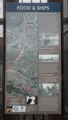
1. Food & Ships Marker
Captions: (top left) Map of the original bay shoreline.; (middle left) Aerial photograph showing the Key Route and Oakland Bay Trail.; (bottom left) Map orienting the above aerial photograph in relation to San Francisco Bay.; (top right) Asparagus cannery in West Oakland, early 1900s.; (middle right) Howard Terminal as it appeared around World War I.; A turbine steamer launching at Moore shipyard, 1917.
By the early 20th century, harbor improvements, expanded port facilities, and transcontinental rail service had made Oakland one of the state's leading exporters of processed food of all kinds: canned, dried, bottled, and baked. Vegetables, fruits and grains were brought in by rail and truck; processed food was exported by rail and ship. Canneries accounted for much of this activity, providing employment for men and women alike. The foremost canner, California Packing Corporation (CPC), formed in 1916 from a merger of several firms, sold its products under the brand name "Del Monte." The brick structure you see here, angling back to Linden Street, was built by CPC in the early 1920s, incorporating older cannery buildings.
The first privately owned cargo facility on the Oakland Estuary, Howard Terminal was established near this spot in 1900, on a 17-acre site at the foot of Filbert Street.
The terminal specialized in bulk commodities like grain, lumber and coal, and it huge coal bunkers loomed over the waterfront for many years. After World War I, when it began handling canned food and other cargoes, the terminal included warehouses and a railway. The site now forms part of the Port of Oakland's Charles P. Howard Container Terminal.
During and after the two world wars, the estuary was one of the busiest shipbuilding ports in the nation. The largest of the local shipyards, Moore Dry Dock (originally Moore & Scott), began operating at the foot of Adeline Street, west of here, in 1909.
The yard produced nearly 60 steel freighters and tankers between 1916 and 1921, setting records for speed of construction and multiple launchings. During World War II, Moore specialized in ship repairs, employing nearly 40,000 workers in an expanded yard covering 128 acres. The shipyard, which also fabricated structural steel for many buildings in the Bay Area, closed in 1961. The site is now occupied by Schnitzer Steel and the Port of Oakland's American President Lines Container Terminal.
Erected by San Francisco Bay Trail, Association of Bay Area Governments and Coastal Conservancy.
Topics. This historical marker is listed in these topic lists: Architecture • Industry & Commerce • Waterways & Vessels.
Location. 37° 48.03′ N, 122° 17.218′ W. Marker is in Oakland, California, in Alameda County. It is in Acorn Industrial. Marker is on 3rd Street near Linden Street, on the right. Touch for map. Marker
is at or near this postal address: 1001 3rd Street, Oakland CA 94607, United States of America. Touch for directions.
Other nearby markers. At least 8 other markers are within walking distance of this marker. Seventh Street (approx. half a mile away); Jefferson Square Park (approx. half a mile away); Estuary Industry (approx. half a mile away); The Port of Oakland (approx. half a mile away); USS Potomac (approx. half a mile away); History of the Transbay Ferry (approx. half a mile away); Evolution of a Marine Terminal (approx. half a mile away); Charles P. Howard Terminal (approx. half a mile away). Touch for a list and map of all markers in Oakland.
Credits. This page was last revised on February 7, 2023. It was originally submitted on February 29, 2016, by Barry Swackhamer of Brentwood, California. This page has been viewed 391 times since then and 11 times this year. Photos: 1, 2. submitted on February 29, 2016, by Barry Swackhamer of Brentwood, California.
