
Near Vienna in Fairfax County, Virginia — The American South (Mid-Atlantic)
Fields of Fire
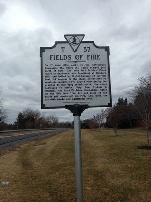
Photographed by Brandon D Cross, February 25, 2016
1. Fields of Fire Marker
Erected 2014 by Department of Historic Resources. (Marker Number T-57.)
Topics and series. This historical marker is listed in this topic list: War, US Civil. In addition, it is included in the Virginia Department of Historic Resources (DHR) series list. A significant historical date for this entry is June 17, 1863.
Location. 38° 58.46′ N, 77° 18.92′ W. Marker is near Vienna, Virginia, in Fairfax County. It is on Hunter Mill Rd (County Route 674) 0.1 miles north of Water Falls Lane, on the right when traveling north. Touch for map. Marker is at or near this postal address:
this page online

Regionally, this marker is in the Washington Metropolitan Area and in Northern Virginia. It is also in the American South, specifically in the Upper South, in the Mid-Atlantic, and on the Eastern Seaboard. Globally, it is in the North Atlantic Region, North America, the Western Hemisphere, the Western World, and the Anglosphere. Historically, it finds itself in what was once the territory of the Mississippian Culture, one of the original Thirteen Colonies, one of the Confederate States of America, and the Antebellum South.
Other nearby markers. At least 8 other markers are within walking distance of this marker: Sacred Ibis (approx. 0.2 miles away); Kune Kune Pig (approx. 0.2 miles away); Budgerigar (approx. 0.2 miles away); African Pygmy Goat (approx. 0.2 miles away); Soay Sheep (approx. 0.2 miles away); White Faced Capuchin (approx. 0.2 miles away); In Memory of Mack S. "Jack" Crippen, Jr. (approx. 0.2 miles away); a different marker also named African Pygmy Goat (approx. ¼ mile away). Touch for a list and map of all markers in Vienna.
Credits. This page was last revised on July 7, 2021. It was originally submitted on March 13, 2016, by Brandon D Cross of Flagler Beach, Florida. This page has been viewed 2,090 times since then and 109 times this year. Photo 1. submitted on March 13, 2016, by Brandon D Cross of Flagler Beach, Florida. • Bernard Fisher was the editor who published this page.
