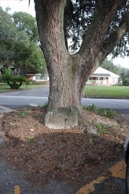
Sanford in Seminole County, Florida — The American South (South Atlantic)
Fort Reid 1836
Established as a commissary and soldiers camp for Fort Mellon
Erected 1934 by Sallie Harrison Chapter D.A.R., Sanford, Florida.
Topics and series. This historical marker is listed in these topic lists: Forts and Castles • Wars, US Indian. In addition, it is included in the Daughters of the American Revolution series list. A significant historical year for this entry is 1836.
Location. 28° 47.509′ N, 81° 15.391′ W. Marker is in Sanford, Florida, in Seminole County. Marker is at the intersection of Grove Manor Drive and Mellonville Avenue, in the median on Grove Manor Drive. Marker is hidden from view from Mellonville Avenue by an oak tree. The tree is in the middle of Grove Manor Drive. Touch for map. Marker is in this post office area: Sanford FL 32771, United States of America. Touch for directions.
Other nearby markers. At least 8 other markers are within 2 miles of this marker, measured as the crow flies. Fort Reid (approx. ¼ mile away); Speer Grove Park (approx. ¼ mile away); Hopper Academy (approx. 0.8 miles away); Georgetown (approx. 0.8 miles away); St. James African Methodist Episcopal Church (approx. one mile away); Dr. Seth French (1824~1896) (approx. 1.1 miles away); Sanford State Farmers' Market (approx. 1.2 miles away); Historical Figures (approx. 1.3 miles away). Touch for a list and map of all markers in Sanford.
Regarding Fort Reid 1836. Note that there is a discrepancy as to the date Fort Reid was established. This plaque states 1836 while the nearby county marker states 1840. Other resources point to 1840 as being the correct date.
Related markers. Click here for a list of markers that are related to this marker. To better understand the relationship, study each marker in the order shown.
Also see . . . Fort Reid. Fortwiki website entry (Submitted on October 29, 2021, by Larry Gertner of New York, New York.)
Credits. This page was last revised on October 29, 2021. It was originally submitted on March 15, 2016, by Tim Fillmon of Webster, Florida. This page has been viewed 602 times since then and 33 times this year. Photos: 1, 2. submitted on March 15, 2016, by Tim Fillmon of Webster, Florida. • Bill Pfingsten was the editor who published this page.

