
Franklinton in Columbus in Franklin County, Ohio — The American Midwest (Great Lakes)
Headquarters of General William H. Harrison
Ohio Revolutionary Memorial Trail

Image courtesy of the Historical Marker Database
1. Headquarters of General William H. Harrison Marker
General William H. Harrison - 1813
»»««
Here, in the War of 1812,
he directed the formation of
his army for the campaign
against the British, resulting
in the victory of the Thames.
Erected 1930 by Ohio Revolutionary Memorial Commission. (Marker Number C.)
Topics and series. This historical marker is listed in these topic lists: Indigenous Peoples and Communities • War of 1812. In addition, it is included in the Ohio Revolutionary Memorial Commission series list. A significant historical year for this entry is 1813.
Location. Marker is missing. It was located near 39° 57.625′ N, 83° 0.948′ W. Marker was in Columbus, Ohio, in Franklin County. It was in Franklinton. It was at the intersection of West Broad Street (U.S. 40) and North Gift Street, on the right when traveling west on West Broad Street. This marker is missing from its location in front of the brick building located on West Broad Street that has been identified as being built on the site of General Harrison's War of 1812 encampment. Touch for map. Marker was at or near this postal address: 570 West Broad Street, Columbus OH 43215, United States of America. Touch for directions.

Regionally, this marker was in Ohio’s Scioto Valley. It was also in the American Midwest and in the Corn Belt. Globally, it was in North America, the Western Hemisphere, the Western World, and the Anglosphere. Historically, it found itself in what was once the Haudenosaunee (Iroquois) Confederacy, the territory of the Mississippian Culture, and the Northwest Territory.
Other nearby markers. At least 8 other markers are within walking distance of this location: Franklinton (here, next to this marker); The Harrison House (a few steps from this marker); a different marker also named Franklinton (a few steps from this
this page online
Another marker is no longer nearby. Lucas Sullivant Home Site (was approx. 0.2 miles away but has been confirmed missing).
More about this marker. This historical marker is part of the Ohio Revolutionary Memorial Trail series (type C) which was put in place in 1930 to celebrate the 150th anniversary of the Ohio's Revolutionary War era Battle of Piqua, by the Ohio Revolutionary Memorial Commission.
In order to accomplish this, in 1929 the state of Ohio created the Ohio Revolutionary Memorial Commission, and then in 1930 this commission created 22 military trails, throughout western Ohio, between Cincinnati, Ohio on the state's southern border and Toledo, Ohio on the state's northern border. Each of these military trails represented the routes,
Photographed by Dale K. Benington, April 6, 2016
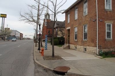
2. Headquarters of General William H. Harrison Marker
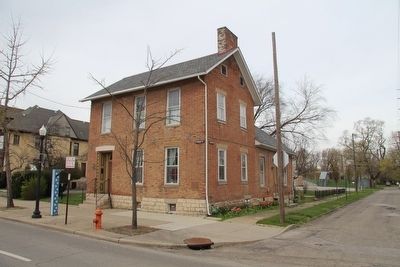
View looking west along West Broad Street, with a view of the brick house (on right) that was built atop General Harrison's War of 1812 encampment. The ORMC marker was probably about where the small tree by the red fire hydrant was located.
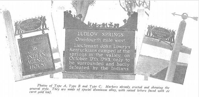
The routes of these military trails were in turn marked by type A and type B Ohio Revolutionary Memorial Commission markers that served as directional (type B) and distance (type A) markers.
Originally, back in 1930, there were erected 70 some of these Ohio Revolutionary Memorial Commission, type C, markers. To date, there are only 20 some of them that have been located and posted on the Historical Marker database. A number of them are presently missing, and presumed to be permanently lost, including this featured marker.
Also see . . . Ohio Revolutionary Memorial Trail. A description of the Revolutionary Memorial Trail System developed by the state of Ohio in 1929 - 1930. (Submitted on April 7, 2016, by Dale K. Benington of Toledo, Ohio.)
Photographed by Dale K. Benington, April 6, 2016
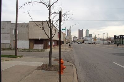
3. Headquarters of General William H. Harrison Marker
View looking east along West Broad Street, towards downtown Columbus. This portion of Broad Street was part of the 1930 Ohio Revolutionary Memorial Trail System, which is why the marker would have been located very near here, probably about where the young tree is, close to the red fire hydrant.
Photographed by Dale K. Benington, April 6, 2016
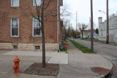
4. Headquarters of General William H. Harrison Marker
View of the probable marker site looking north along Gift Street. In the background, a plaque can be seen on the brick house, commemorating the site of General Harrison's encampment.
Photographed by Dale K. Benington, April 6, 2016
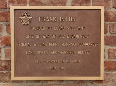
5. Headquarters of General William H. Harrison Marker
Close-up view of the nearby plaque that commemorates this area as being the site of the War of 1812 encampment of General William Henry Harrison.
Photographed by Dale K. Benington, April 6, 2016
6. Headquarters of General William H. Harrison Marker
A distant view of both the probable ORMC marker site (small tree by red fire hydrant) and the War of 1812 encampment site (general area where brick house is located).
Photographed by Ohio Revolutionary Memorial Commission
7. Ohio Revolutionary Memorial Commission Marker Types
View of the three types of markers used by the Ohio Revolutionary Memorial Commission. The marker on the left is a type A marker, the marker in the middle is a type C (just like our missing marker), and the marker on the right is a type B.
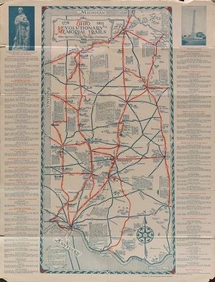
Image courtesy of the MidPointe Library System (www.MidPointeLibrary.org)
8. Ohio Revolutionary Memorial Trail Map
A view of an original Ohio Revolutionary Memorial Trail Map, from 1930. For a better view double click on this picture.
Credits. This page was last revised on February 3, 2023. It was originally submitted on April 7, 2016, by Dale K. Benington of Toledo, Ohio. This page has been viewed 721 times since then and 33 times this year. Photos: 1. submitted on April 7, 2016. 2, 3, 4, 5, 6. submitted on April 7, 2016, by Dale K. Benington of Toledo, Ohio. 7, 8. submitted on April 20, 2016, by Dale K. Benington of Toledo, Ohio.
