La Paz Centro, León, Nicaragua — Central America
Ruins of Old León
Cultural Heritage of Humanity
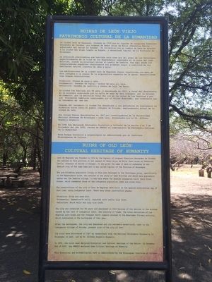
— Ruinas de León Viejo · Patrimonio Cultural de la Humanidad —
La población precolombina que habitaba esta zona era del grupo de los Chorotegas, específicamente de la tribu de los Nagrandos, asentado en la costa del lago Xolotlán, siendo su principal núcleo el pueblo de Imabite. Fue aquí donde los conquistadores españoles construyeron sus primeras casas, a similitud de los habitantes nativos (ranchos de caña y paja).
Las edificaciones de la ciudad León de Nagrando fueron construidos con mano de obra indígena a la usanza de la arquitectura española de la época, desarrollando tres etapas constructivas:
Primitiva: Chozas de paja y caña.
Fundamental: Paredes de tapial, techos de paja y/o teja.
Definitiva: Paredes de ladrillo y techos de teja de barro.
La ciudad fue habitada por 86 años, y abandonada en 1610, a causa del decaimiento en la economía ocasionado por la falta de mano de obra indígena, por la escasez de comercio, por la extinción total del oro en la minas de Las Segovias y por los frecuentes temblores ocasionados por el Volcán Momotombo, que culminaron con el terremoto de ese año.
Después del terremoto la ciudad fue abandonada y sus pobladores se trasladaron en dirección norte junto al pueblo indígena de Sutiaba, emplazamiento actual de la ciudad de León.
Sus ruinas fueron descubiertas en 1967 por investigadores de la Universidad Nacional Autónoma de Nicaragua – sede León, encabezados por el Dr. Alfonso Arguello Arguello.
En 1994 fue declarado Patrimonio Histórico y Cultural de la Nación y el 2 de Diciembre del año 2000, recibe de UNESCO el nombramiento de Patrimonio Cultural de la Humanidad.
Este Parque histórico y arqueológico es administrado por el Instituto Nicaraguense de Cultura.
English:
Ruins of Old León
Cultural Heritage of Humanity
León de Nagrando was founded in 1524 by the Captain of conquest Francisco Hernández de Córdoba, who settled in this province at the request of Pedro Arias de Ávila (best known as Pedrarias Dávila, Governor of Darién in Panama). It was given the name of León in reference to the Spanish city of the same name and it was called Capital of the Province of Nicaragua.
The pre-Columbian population living in this area belonged to the Chorotegas group, specifically to the Nagrandos tribe, who settled on the shore of Lake Xolotlán and whose main population center was the Imabite village. It was here where the Spanish conquerors built their first houses, which resembled those of the indigenous population (reed and straw huts).
The constructions of the city of León de Nagrando were built in the Spanish architecture way of that time, using indigenous labor. There were three construction phases:
Primitive: Straw and reed huts.
Fundamental: Rammed-earth walls, thatched roofs and/or tile roofs.
Definitive: Brick walls and clay tile roofs.
The city was inhabited for 86 years and abandoned in 1610 because of the decline in the economy cause by the lack of indigenous labor, the scarcity of trade, the total extinction of Las Segovias gold mines and the frequent earth tremors related to the Momotombo Volcano activity, which culminated in the earthquake of that year.
After the earthquake, the city was abandoned and its residents moved north, next to the indigenous village of Sutiaba, present site of the city of León.
Its ruins were discovered in 1967 by researchers from the National Autonomous University of Nicaragua in León, led by Dr. Alfonso Arguello Arguello.
In 1994, the ruins were declared Historical and Cultural Heritage of the Nation. On December 2nd of 2000, the UNESCO declared them Cultural Heritage of Humanity.
This Historical and Archaeological Park is administered by the Nicaraguan Institute of Culture.
Topics and series. This
historical marker is listed in these topic lists: Colonial Era • Settlements & Settlers. In addition, it is included in the UNESCO World Heritage Sites series list. A significant historical date for this entry is December 2, 1524.
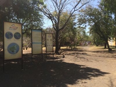
Location. 12° 24.159′ N, 86° 36.964′ W. Marker is in La Paz Centro, León. The marker is on the grounds of the León Viejo Archaeological Park, near the entrance to the park. Touch for map. Touch for directions.
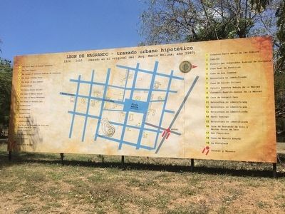
Other nearby markers. At least 8 other markers are within walking distance of this marker. “The Palace of Governor Rodrigo de Contreras” (about 90 meters away, measured in a direct line); "The House of Hernando de Soto and Hernán Ponce de León" (about 90 meters away); "The House of Martín" (about 150 meters away); “The Saint Mary of Graces Cathedral” (about 150 meters away); "The Town Square" (about 150 meters away); “The Town Council” (about 180 meters away); “The House of Ana Jiménez” (about 210 meters away); "The Royal Road" (about 210 meters away). Touch for a list and map of all markers in La Paz Centro.
Credits. This page was last revised on June 16, 2016. It was originally submitted on April 10, 2016, by J. Makali Bruton of Accra, Ghana. This page has been viewed 300 times since then and 12 times this year. Photos: 1, 2, 3. submitted on April 10, 2016, by J. Makali Bruton of Accra, Ghana.


