West Ocean View in Norfolk, Virginia — The American South (Mid-Atlantic)
USS Intrepid (CV-11)
Photographed by Kevin W., April 28, 2016
1. USS Intrepid (CV-11) Marker
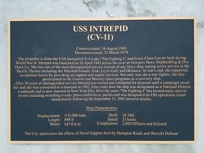
Decommissioned: 15 March 1974
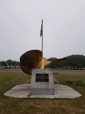
The propeller is from the USS Intrepid (CV-11) aka "The Fighting I", an Essex Class Carrier built during World War II. Intrepid was launched on 26 April 1943 across the river at Newport News Shipbuilding & Dry Dock Co. She has one of the most distinguished service records of any Navy ship, seeing active service in the Pacific Theater including the Marshall Islands. Truk, Leyte Gulf, and Okinawa. At war's end, she supported occupation forces by providing air support and supply services. Not only was she a war fighter, she also participated in the Gemini and Mercury space programs as a recovery ship.
After 30 years of distinguished service Intrepid was retired and scheduled for disposal until a campaign saved her and she was converted to a museum in 1982. Four years later the ship was designated as a National Historic Landmark and is now moored in New York City. Over the years "The Fighting I" has hosted many special events including wrestling events, press conferences, parties and was designated an FBI operations center immediately following the September
this page online
Ship Characteristics
Displacement: >33,000 tons
Draft: 28-34ft
Length: 898 ft
Speed: 33 knots
Beam: 147 ft 6 in
Complement: 2,600 Officers and Enlisted
The City appreciates the efforts of Naval Support Activity Hampton Roads and Wartsila Defense
Erected by City of Norfolk.
Topics. This historical marker is listed in these topic lists: War, World II • Waterways & Vessels. A significant historical date for this entry is April 26, 1943.
Location. 36° 57.485′ N, 76° 15.566′ W. Marker is in Norfolk, Virginia. It is in West Ocean View. It is at the intersection of West Ocean View Avenue (U.S. 60) and Tidewater Drive (Virginia Route 168) on West Ocean View Avenue. Touch for map. Marker is in this post office area: Norfolk VA 23503, United States of America. Touch for directions.

Regionally, this marker is in Virginia’s Hampton Roads, specifically in Coastal Virginia, and in the Hampton Roads Metropolitan Area. It is also in the American South, specifically in the Upper South, in the Tidewater, and on the Eastern Seaboard. Globally, it is in the North Atlantic Region, North America, the
Photographed by Kevin W., April 28, 2016
2. USS Intrepid (CV-11) Marker
Other nearby markers. At least 8 other markers are within 2 miles of this marker, measured as the crow flies: Susan Constant Shrine (about 300 feet away, measured in a direct line); Operation Torch, 1942 (about 500 feet away); Flagship Sarah Constant (about 500 feet away); a different marker also named Landing of Wool and Surrender of Norfolk (approx. 0.2 miles away); OceanView Veterans Memorial (approx. 0.3 miles away); First Flight Ship to Shore (approx. 0.4 miles away); Veterans Memorial (approx. half a mile away); Naval Air Station Norfolk (approx. 1.2 miles away). Touch for a list and map of all markers in Norfolk.
Another marker is no longer nearby. Landing of Wool and Surrender of Norfolk (was approx. 0.2 miles away but has been replaced with another marker now near it).
Photographed by Kevin W., April 28, 2016
3. USS Intrepid (CV-11) Marker
Credits. This page was last revised on February 1, 2023. It was originally submitted on April 29, 2016, by Kevin W. of Stafford, Virginia. This page has been viewed 690 times since then and 79 times this year. Photos: 1, 2, 3. submitted on April 29, 2016, by Kevin W. of Stafford, Virginia.
