Jackson in Amador County, California — The American West (Pacific Coastal)
Argonaut Mine
Photographed by James King, January 26, 2014
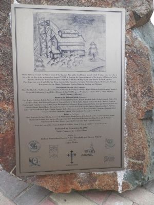
1. Argonaut Mine Marker
On the hill to your right stand the remains of the Argonaut Mine gallus (headframe), beneath which 47 miners were lost when a fire broke out deep in the main shaft on August 27, 1922. At that time the Argonaut was one of the deepest gold mines in North America. The disaster that occurred on that fateful day is noted as the largest gold mine disaster in North America. These brave men were from California, Texas, Austria, Italy, Yugoslavia, Germany, Switzerland, Spain, Montenegro, Portugal, Hercegovina, Serbia, Illinois, Washington, Sweden, Dalmatia, Sardinia and Michigan.
this page online
“From the Lowest Place Unto the Highest, God Has Taken 47 Sons of Amador” - Stockton Record 1922
funding by
Italian Benevolent Society • Dr. Elizabeth and Steven Pinotti
Artwork by
Cotdy Fisher
Erected 2007 by Native Sons of the Golden West with the Native Daughters of the Golden West,
Photographed by James King, January 26, 2014
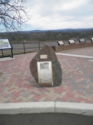
2. Argonaut Mine Monument
Topics and series. This historical marker is listed in these topic lists: Cemeteries & Burial Sites • Disasters • Industry & Commerce. In addition, it is included in the Native Sons/Daughters of the Golden West series list. A significant historical year for this entry is 1922.
Location. 38° 21.888′ N, 120° 47.23′ W. Marker is in Jackson, California, in Amador County. It is on State Highway 49 (California Route 49), on the right when traveling south. Marker is located at the rest area across from the Kennedy Mine, 1.6 miles north of the town of Jackson. Touch for map. Marker is in this post office area: Jackson CA 95642, United States of America. Touch for directions.

Regionally, this marker is in California’s Gold Country and in the Sierra Nevada. It is also in the American Mountain West. Globally, it is in North America, on the Pacific Rim, in the Western Hemisphere, in the Western World, and in the Anglosphere. Historically, it finds itself in what was once New Spain and also
Photographed by James King, January 26, 2014
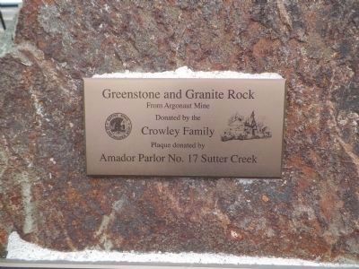
3. Greenstone and Granite Rock
Donated by the
Crowley Family
Plaque donated by
Amador Parlor No. 17 Sutter Creek
Other nearby markers. At least 8 other markers are within walking distance of this marker: Jackson (here, next to this marker); The Kennedy Mine / The Argonaut Mine (here, next to this marker); University of California Foothill Field Station (a few steps from this marker); Argonaut and Kennedy Mines (a few steps from this marker); Anthony Caminetti (a few steps from this marker); Amador County Veterans' Memorial (a few steps from this marker); Kennedy Mining and Milling Company (approx. 0.4 miles away); Kennedy Mine Headframe (approx. 0.4 miles away). Touch for a list and map of all markers in Jackson.
Related markers. Click here for a list of markers that are related to this marker. Additional information on the victim's burial sites.
Also see . . .
1. Argonaut Mine. Wikepedia entry (Submitted on August 9, 2022, by Larry Gertner of New York, New York.)
2. 1922 Gold Mine Disaster Was State's Deadliest. Los Angeles Times website entry (Submitted on March 3, 2014, by James King of San Miguel, California.)
Photographed by James King, January 26, 2014
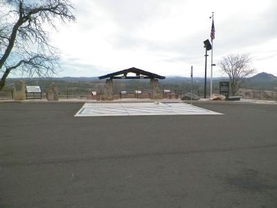
4. Argonaut Mine Monument
The stele of the Jackson marker is at the extreme left, this marker is on the boulder just to the right. The two boulders to the right of the shelter are the UC Foothill Field Station Marker and the Argonaut and Kennedy Mines marker.
Credits. This page was last revised on August 9, 2022. It was originally submitted on March 2, 2014, by James King of San Miguel, California. This page has been viewed 1,404 times since then and 53 times this year. Last updated on May 22, 2016, by James King of San Miguel, California. Photos: 1. submitted on March 2, 2014, by James King of San Miguel, California. 2, 3, 4. submitted on March 3, 2014, by James King of San Miguel, California. • Syd Whittle was the editor who published this page.
