Union City in Branch County, Michigan — The American Midwest (Great Lakes)
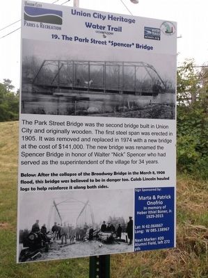
The Park Street "Spencer" Bridge
Union City Heritage Water Trail

Photographed By Val Rossman, June 16, 2016
1. The Park Street "Spencer" Bridge Marker
Union City Heritage Water Trail website entry #19
Click for more information.
Click for more information.
Erected 2016 by Union City Heritage Water Trail. (Marker Number 19.)
Topics and series. This historical marker is listed in these topic lists: Bridges & Viaducts • Waterways & Vessels. In addition, it is included in the Michigan - Union City Heritage Water Trail series list. A significant historical year for this entry is 1905.
Location. 42° 3.88′ N, 85° 8.338′ W. Marker is in Union City, Michigan, in Branch County. This marker is on private property please do not attempt to access it by trespassing on foot. It is meant to be viewed by paddling the St. Joseph River as part of the Union City Heritage Water Trail. It is on the south bank of the river upstream from the Park St. Bridge. Touch for map. Marker is in this post office area: Union City MI 49094, United States of America. Touch for directions.
Other nearby markers. At least 8 other markers are within walking distance of this marker. The French & Trading Posts (about 600 feet away, measured in a direct line); Union City Milling and Mill Race Outlet (about 700 feet away); Alumni Field (approx. 0.2 miles away); Union City Methodist Episcopal Church (approx. 0.2 miles away); The Flood of 1908 & Broadway Bridge "Island" (approx. 0.2 miles away); Riverview Park (approx. 0.2 miles away); Titlow House & Parachute Factory (approx. 0.2 miles away); Chivas & Jack's Grocery (approx. ¼ mile away). Touch for a list and map of all markers in Union City.
More about this marker. . There are 28 of these markers comprising the Union City Heritage Water Trail on the Coldwater River and the St. Joseph River launched in 2016 for the village's Sesquicentennial. These markers can be viewed by paddling the 5 mile stretch of river from the JP Palmer Launch in the Village of Union City to the Riley Dam on the SW Corner of Union Lake. Most of these markers CANNOT by accessed by foot as they are on private property along the river. Please do not trespass. More details can be found at www.uchwt.com
Credits. This page was last revised on April 9, 2022. It was originally submitted on June 16, 2016, by Val Rossman of Union City, Michigan. This page has been viewed 233 times since then and 9 times this year. Photo 1. submitted on June 16, 2016, by Val Rossman of Union City, Michigan. • Bill Pfingsten was the editor who published this page.
Editor’s want-list for this marker. View of marker in context • Can you help?