Auburn in Placer County, California — The American West (Pacific Coastal)
Western States Endurance Run Finish Line
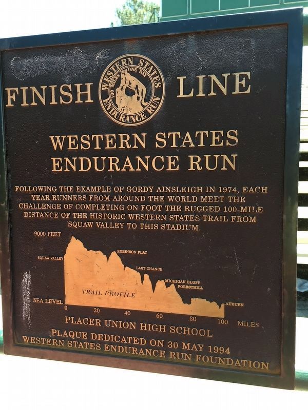
Photographed by Greg Bettencourt, July 13, 2016
1. Western States Endurance Run Finish Line Marker
Click on photo to view the trail profile.
Erected 1994 by Placer Lake High School and Western States Endurance Run Foundation.
Topics. This historical marker is listed in these topic lists: Notable Events • Sports. A significant historical year for this entry is 1974.
Location. 38° 53.684′ N, 121° 4.062′ W. Marker is in Auburn, California, in Placer County. It can be reached from Stadium Way 0.2 miles Finley Street. Can be seen at the base of the stadium bleacher seats, on the track. Touch for map. Marker is in this post office area: Auburn CA 95603, United States of America. Touch for directions.

Regionally, this marker is in California’s Sacramento Metro and in the Sierra Nevada. It is also in the American Mountain West. Globally, it is in North America, on the Ring of Fire, on the Pacific Rim, in the Western Hemisphere,
this page online
Other nearby markers. At least 8 other markers are within walking distance of this marker: The Historic Cooper Amphitheater (approx. 0.3 miles away); Central Square (approx. 0.3 miles away); The Auburn Masonic Hall (approx. 0.3 miles away); Placer County Museum (approx. 0.4 miles away); Camp Flint (approx. 0.4 miles away); Location of Camp Flint (approx. 0.4 miles away); The Little Fair That Wouldn't Die (approx. 0.4 miles away); Gold Discovered Just Downstream in Auburn Ravine! - Why Daylight North Rich Ravine? (approx. 0.4 miles away). Touch for a list and map of all markers in Auburn.
Credits. This page was last revised on July 16, 2016. It was originally submitted on July 13, 2016, by Greg Bettencourt of Roseville, California. This page has been viewed 782 times since then and 30 times this year. Photo 1. submitted on July 13, 2016, by Greg Bettencourt of Roseville, California. • Syd Whittle was the editor who published this page.
Editor’s want-list for this marker. Wide area view of the marker and its surroundings. • Can you help?
