Near Charles City in Charles City County, Virginia — The American South (Mid-Atlantic)
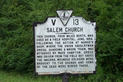
Salem Church
Erected 1934 by Conservation and Development Commission. (Marker Number V-13.)
Topics and series. This historical marker is listed in these topic lists: Churches & Religion • War, US Civil. In addition, it is included in the Virginia Department of Historic Resources (DHR) series list. A significant historical year for this entry is 1864.
Location. 37° 20.246′ N, 77° 9.992′ W. Marker is near Charles City, Virginia, in Charles City County. Marker is at the intersection of John Tyler Memorial Highway (Virginia Route 5) and Barnetts Road (Virginia Route 609), on the right when traveling west on John Tyler Memorial Highway. Touch for map. Marker is in this post office area: Charles City VA 23030, United States of America. Touch for directions.
Other nearby markers. At least 8 other markers are within 2 miles of this marker, measured as the crow flies. Westover Church (approx. 0.4 miles away); a different marker also named Westover Church (approx. half a mile away); Evelynton (approx. 0.8 miles away); Herring Creek (approx. one mile away); Stuart's Ride (approx. 1.2 miles away); Emanuel Quivers (approx. 1.4 miles away); First English Thanksgiving in Virginia (approx. 1.4 miles away); Berkeley Plantation or Harrison's Landing (approx. 1.4 miles away). Touch for a list and map of all markers in Charles City.
Credits. This page was last revised on June 16, 2016. It was originally submitted on July 27, 2008, by Kathy Walker of Stafford, Virginia. This page has been viewed 1,148 times since then and 40 times this year. Photo 1. submitted on July 27, 2008, by Kathy Walker of Stafford, Virginia. • Craig Swain was the editor who published this page.
