Emmitsburg in Frederick County, Maryland — The American Northeast (Mid-Atlantic)
Mount Saint Mary's College
Photographed by Craig Swain, June 22, 2008
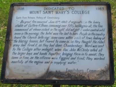
1. Mount Saint Mary's College Marker
Dedicated to
Mount Saint Mary's College
Quote from Helmans History of Emmitsburg:
"- The great fire occurred June 15th, 1863 it originated in the livery stable of Guthrie & Beam, consuming over fifty buildings in all; the fire commenced at eleven o'clock in the night, did not get it under control until seven in the morning; the hotel was the last to burn. People in the country heard the Church bells ring; some came within a mile of town, looking at the blazing houses, but feared to come in, as they thought the rebel army had fired it, as they had done Chambersburg. Word was sent to the College after midnight, when Rev. John McClosky called all the larger boys and hands together, bringing them in to assist; they came in time, as the citizens were fagged and tired; they worked manfully at the engine and in supplying water."
Erected by Emmitsburg Community.
Topics. This historical marker is listed in these topic lists: Disasters • War, US Civil. A significant historical date for this entry is June 15, 1810.
Location. Marker has been reported missing. It was located near 39° 42.115′ N, 77° 19.67′ W. Marker was in Emmitsburg,
this page online

Regionally, this marker was in the Washington Metropolitan Area and in Central Maryland. It was also in the American Mid-Atlantic. Globally, it was in North America, the Western Hemisphere, the Western World, and the Anglosphere. Historically, it found itself in what was once one of the original Thirteen Colonies and also the Antebellum South.
Other nearby markers. At least 8 other markers are within walking distance of this location: Army of the Potomac (within shouting distance of this marker); a different marker also named Army of the Potomac (within shouting distance of this marker); The Emmitsburg Railroad (within shouting distance of this marker); Emmitsburg High School (within shouting distance of this marker); Volunteers Mural (within shouting distance of this marker); A Building With Many Lives (about 300 feet away, measured in a direct line); The Carriage House Inn (about 400
Photographed by Craig Swain
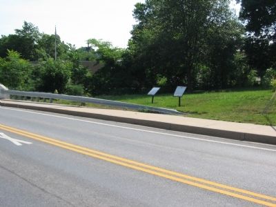
2. Markers near the Willow Rill Bridge
Two markers stand next to the Willow Rill Bridge on Business U.S. 15 through Emmitsburg. On the left is the Emmitsburg Sisters of Charity marker. On the left is the Mount Saint Mary's College marker.
Another marker is no longer nearby. Emmitsburg Sisters of Charity (was here, next to this marker but has been confirmed missing).
Also see . . .
1. Mount Saint Mary's University - Our History. University website entry (Submitted on July 27, 2008, by Craig Swain of Leesburg, Virginia.)
2. The Great Fire of June, 1863. Emmitsburg Area Historical Society website entry (Submitted on July 27, 2008, by Craig Swain of Leesburg, Virginia.)
Additional commentary.
1. Burning of Chambersburg
The quote mentions the burning of Chambersburg, Pennsylvania. However, the town in Pennsylvania, was not burned by the Confederates until a year later (1864). One should also note, although the Confederate armies were in full motion by June 15, 1863, most were still well south of the Potomac engaged in fighting around the city of Winchester and Loudoun County, Virginia.
— Submitted July 27, 2008, by Craig Swain of Leesburg, Virginia.
Credits. This page was last revised on February 26, 2022. It was originally submitted on July 27, 2008, by Craig Swain of Leesburg, Virginia. This page has been viewed 1,721 times since then and 16 times this year. Photos: 1, 2. submitted on July 27, 2008, by Craig Swain of Leesburg, Virginia.
