Near Neligh in Antelope County, Nebraska — The American Midwest (Upper Plains)
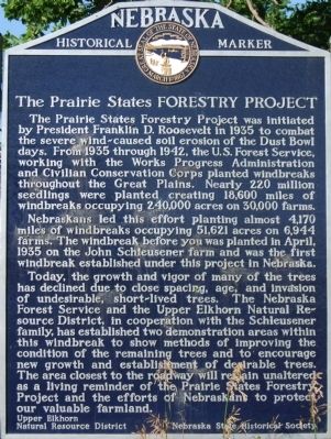
The Prairie States Forestry Project
Photographed by Dawn Bowen, July 27, 2008
1. The Prairie States Forestry Project Marker
Nebraskans led this effort planting almost 4,170 miles of windbreaks occupying 51,621 acres on 6,944 farms. The windbreak before you was planted in April, 1935 on the John Schleusener farm and was the first windbreak established under this project in Nebraska.
Today, the growth and vigor of many of the trees has declined due to close spacing, age, and invasion of undesirable, short-lived trees. The Nebraska Forest Service and the Upper Elkhorn Natural Resource District, in cooperation with the Schleusener family, has established two demonstration areas within this windbreak to show methods of improving the condition of the remaining trees and to encourage new growth
this page online
Erected by Upper Elkhorn Natural Resource District; Nebraska State Historical Society. (Marker Number 296.)
Topics and series. This historical marker is listed in these topic lists: Agriculture • Horticulture & Forestry. In addition, it is included in the Civilian Conservation Corps (CCC), the Nebraska State Historical Society, and the Works Progress Administration (WPA) projects series lists. A significant historical month for this entry is April 1935.
Location. 42° 7.77′ N, 98° 1.68′ W. Marker is near Neligh, Nebraska, in Antelope County. It is on East 5th Street 1.4 miles north of Orchard, on the left when traveling north. It is at the Pierson Wildlife Museum Learning Center. Touch for map. Marker is at or near this postal address: 205 E 5th St, Neligh NE 68756, United States of America. Touch for directions.

Regionally, this marker is in Eastern Nebraska. It is also in the American Midwest, in the Corn Belt, and

Photographed by Dawn Bowen, July 27, 2008
2. The Prairie States Forestry Project Marker at its Original Location
It is shown on 513 Avenue, 1.4 miles north of Orchard NE 68764.
Other nearby markers. At least 8 other markers are within 12 miles of this marker, measured as the crow flies: The Rainbow Fountain (approx. ¼ mile away); The Neligh Mills (approx. ¼ mile away); Trails, Rails, and Roads: Lifelines of a Mill (approx. ¼ mile away); Water Power at the Neligh Mill (approx. ¼ mile away); The Neligh Mill Bridge (approx. 0.3 miles away); Ponca Trail of Tears (approx. ¾ mile away); Tilden, Nebraska (approx. 11.4 miles away); Tilden Veterans Memorial (approx. 11.6 miles away). Touch for a list and map of all markers in Neligh.
More about this marker. It was located near 42° 21.424′ N, 98° 14.57′ W near Orchard, Nebraska 68764, in Antelope County. It was on 513 Avenue, 1.4 miles north of Orchard, on the left when traveling north.
Additional commentary.
1. Marker removed in 2017
The History Nebraska website list of Nebraska Historical markers notes the marker was removed in 2017 as the windbreak, mentioned

Photographed by Dawn Bowen, July 27, 2008
3. South View of Windbreak
This windbreak is at the original location of this marker, on 513 Avenue, 1.4 miles north of Orchard NE 68764. In 2017 the windbreak was removed.
— Submitted June 18, 2021, by Mark Hilton of Montgomery, Alabama.
2. New location
The marker is now on the grounds of the Pierson Wildlife Museum Learning Center at 205 E 5th St, Neligh, NE 68756
— Submitted June 15, 2025, by Jimmy Emerson of Dalton, Georgia.
Credits. This page was last revised on August 9, 2025. It was originally submitted on July 28, 2008, by Dawn Bowen of Fredericksburg, Virginia. This page has been viewed 3,397 times since then and 92 times this year. Photos: 1, 2, 3. submitted on July 28, 2008, by Dawn Bowen of Fredericksburg, Virginia. • Kevin W. was the editor who published this page.
Editor’s want-list for this marker. Photos of the marker at this, its new location. One close up and one wide shot showing it in its environment. • Can you help?
