West Trenton in Ewing Township in Mercer County, New Jersey — The American Northeast (Mid-Atlantic)
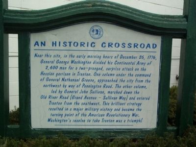
An Historic Crossroad
Topics. This historical marker is listed in these topic lists: Roads & Vehicles • War, US Revolutionary. A significant historical date for this entry is December 26, 1776.
Location. 40° 15.963′ N, 74° 49.141′ W. Marker is in Ewing Township, New Jersey, in Mercer County. It is in West Trenton. Marker is at the intersection of Bear Tavern Road and West Upper Ferry Road, on the left when traveling south on Bear Tavern Road. This marker is at the rear of a small park. Touch for map. Marker is in this post office area: Trenton NJ 08628, United States of America. Touch for directions.
Other nearby markers. At least 8 other markers are within 2 miles of this marker, measured as the crow flies. Church Cemetery (approx. 1.1 miles away); In Memory of their Revolutionary Ancestors (approx. 1.2 miles away); Hopewell Church (approx. 1.3 miles away); Mercer Airport (approx. 1.3 miles away); Bear Tavern Road (approx. 1.9 miles away); Geography & Historic Landscape of Jacobs Creek (approx. 2.1 miles away); Washington’s March to Trenton (approx. 2.1 miles away); Bridges, Roads, and Railroads of Jacobs Creek (approx. 2.1 miles away). Touch for a list and map of all markers in Ewing Township.
More about this marker. This area is commonly called West Trenton. In colonial times it was referred to as Birmingham.
Bear Tavern Road turns into Grand Avenue after it crosses W. Upper Ferry Road. W. Upper Ferry Road turns into Parkway Avenue which connects with Pennington Road when it reaches the city of Trenton.
Credits. This page was last revised on February 7, 2023. It was originally submitted on August 3, 2008, by Gary Nigh of Trenton, New Jersey. This page has been viewed 1,190 times since then and 17 times this year. Photos: 1, 2. submitted on August 3, 2008, by Gary Nigh of Trenton, New Jersey. • Kevin W. was the editor who published this page.

