Near Marion in Marion County, South Carolina — The American South (South Atlantic)
Bowling Green
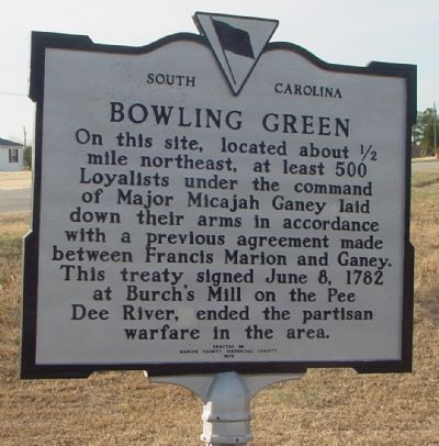
November 16, 2005
1. Bowling Green Marker
Erected 1978 by Marion County Historical Society. (Marker Number 34-8.)
Topics and series. This historical marker is listed in these topic lists: Notable Events • War, US Revolutionary. In addition, it is included in the South Carolina Historical Markers series list. A significant historical date for this entry is June 8, 1818.
Location. 34° 14.793′ N, 79° 24.456′ W. Marker is near Marion, South Carolina, in Marion County. It is on Highway 501 (U.S. 501) near General Place, on the right when traveling north. It is north of Marion on the road to Latta past where Business 501 rejoins Highway 501. Touch for map. Marker is in this post office area: Marion SC 29571, United States of America. Touch for directions.

Regionally, this marker is in South Carolina’s Pee Dee. It is also in the American South
this page online
Other nearby markers. At least 8 other markers are within 5 miles of this marker, measured as the crow flies: Moody Cemetery (approx. ¾ mile away); Ebenezer Church (approx. 2.7 miles away); Antioch Baptist Church (approx. 3.4 miles away); Bluefields (approx. 3.9 miles away); Marion Depot (approx. 4.4 miles away); Marion County Museum (approx. 4.7 miles away); Marion Academy (approx. 4.7 miles away); Naval Gun (approx. 4.7 miles away). Touch for a list and map of all markers in Marion.
Credits. This page was last revised on June 16, 2016. It was originally submitted on November 29, 2005. This page has been viewed 3,346 times since then and 166 times this year. Last updated on August 5, 2008. Photo 1. submitted on November 29, 2005. • Kevin W. was the editor who published this page.
