Port Byron in Cayuga County, New York — The American Northeast (Mid-Atlantic)
The Erie Canal in Port Byron
Erie Canal Heritage Park at Port Byron
— Today's Canal System in New York —
The Erie Canal in Port Byron
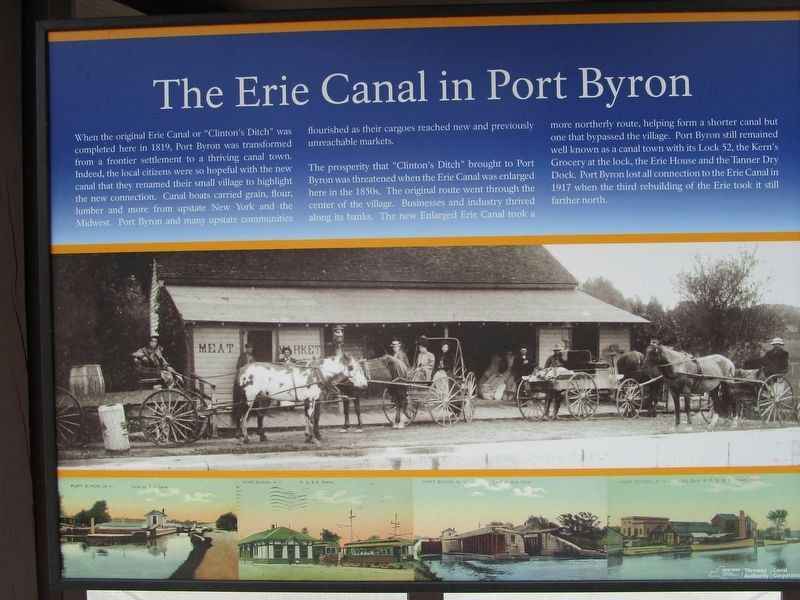
When the original Erie Canal or "Clinton's Ditch" was completed here in 1819, Port Byron was transformed from a frontier settlement to a thriving canal town. Indeed, the local citizens were so hopeful with the new canal that they renamed their small village to highlight the new connection. Canal boats carried grain, flour, lumber and more from upstate New York and the Midwest. Port Byron and many upstate communities flourished as their cargoes reached the new and previously unreachable markets.
The prosperity that "Clinton's Ditch" brought to Port Byron was threatened when the Erie Canal was enlarged here in the 1850s. The original route went through the center of the village. Businesses and industry thrived along its banks. The new Enlarged Erie Canal took a more northerly route, helping form a shorter canal but one that bypassed the village. Port Byron still remained well known as a canal town with its Lock 52, the Kern's Grocery at the lock, the Erie House and the Tanner Dry Dock. Port Byron lost all connection to the Erie Canal in 1917 when the third rebuilding of the Erie took it still farther north.
Erie Canal Heritage Park at Port Byron
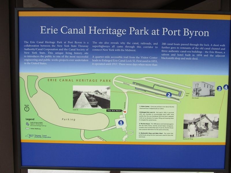
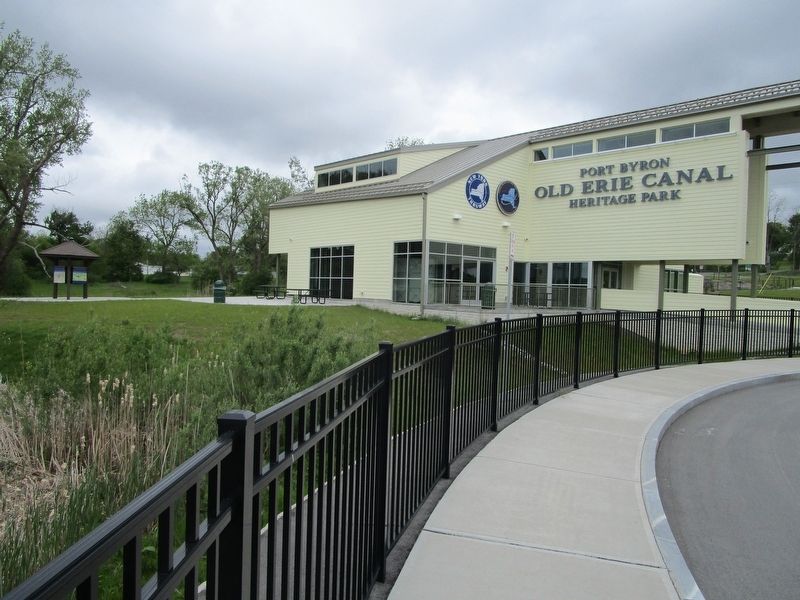
The Erie Canal Heritage Park at Port Byron is a collaboration between the New York State Thruway Authority/Canal Corporation and the Canal Society of New York State. This unique living history site re-introduces the public to one of the most successful engineering and public works projects ever undertaken in the United States.
The site also reveals why the canal, railroads, and superhighways all came through this corridor to connect New York with the Midwest.
A quarter-mile accessible trail from the Visitor Center leads to the Enlarged Erie Canal Lock 52. First used in 1853, it operated until 1917. There were days when more than 200 canal boats passed through the lock. A short walk further [sic] goes to remnants of the old Erie House, a saloon and hotel built in 1894 and the adjacent blacksmith shop and mule shed.
1. Visitor Center - Come see and learn more about the Erie Canal and how it helped build our nation.
2. Enlarged Erie Lock 52 - First used in 1853, it was built with two chambers to accommodate boat traffic more quickly than the one-chambered 1819 lock that it replaced. Locks act as elevators for boats, lifting and lowering them to navigate the varied terrain.
3. The Erie House - This 1894 saloon and hotel belonged to the Van Detto family, recently arrived Italian immigrants. Located a few hundred feet east of Loak 52, the Erie House was a popular destination for the local community.
4. Blacksmith Shop and Mule Shed - The mules that pulled boats along the Erie Canal were cared for here, fed and shoed.
Today's Canal System in New York
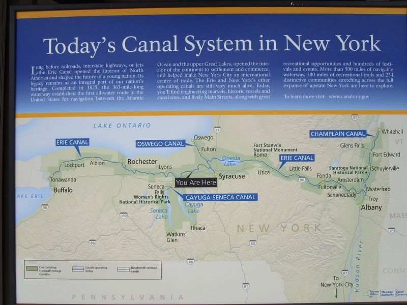
Long before railroads, interstate highways, or jets the Erie Canal opened the interior of North America and shaped the future of a young nation. Its legacy remains as an integral part of our nation's heritage. Completed in 1825, the 363-mile-long waterway established the first all-water route in the United States for navigation between the Atlantic Ocean and the upper Great Lakes, opened the interior of the continent to settlement and commerce, and helped make New York City an international center of trade. The Erie and New York's other operating canals are still very much alive. Today, you'll find engineering marvels, historic vessels and canal sites, and lively Main Streets, along with great recreational opportunities and hundreds of festivals and events. More than 500 miles of navigable waterway, 300 miles of recreational trails and 234 distinctive communities stretching across the full expanse of upstate New York are here to explore.
To learn more visit: www.canals.ny.gov
Erected 2016 by New York State Thruway Authority / Canal Corporation.
Topics and series. This historical marker is listed in these topic lists: Man-Made Features • Settlements & Settlers • Waterways & Vessels. In addition, it is included in the Erie Canal series list. A significant historical year for this entry is 1819.
Location. 43° 2.181′ N, 76° 38.153′ W. Marker is in Port Byron, New York, in Cayuga County. Marker can be reached from Interstate 90. The marker is in Erie Canal Heritage Park, an historical interpretive site / rest area, off of eastbound Interstate 90. Touch for map. Marker is in this post office area: Port Byron NY 13140, United States of America. Touch for directions.
Other nearby markers. At least 8 other markers are within walking distance of this marker. Port Byron's Lock 52 (within shouting distance of this marker); Tanner's Dry Dock (about 300 feet away, measured in a direct line); The Erie House (about 500 feet away); Blacksmith Shop and Mule Shed (about 700 feet away); Glaciers, Drumlins, and High Level Lakes (about 700 feet away); Henry Wells (approx. ¼ mile away); Brigham Young (approx. 0.6 miles away); Amos S. King (approx. 0.6 miles away). Touch for a list and map of all markers in Port Byron.
More about this marker. No restrooms or concessions on site.
Credits. This page was last revised on May 22, 2017. It was originally submitted on May 22, 2017, by Anton Schwarzmueller of Wilson, New York. This page has been viewed 420 times since then and 32 times this year. Photos: 1, 2, 3, 4. submitted on May 22, 2017, by Anton Schwarzmueller of Wilson, New York.


