Memphis in Shelby County, Tennessee — The American South (East South Central)
Donaldsonville, Louisiana/Bayou Lafourche/Geismar, Louisiana
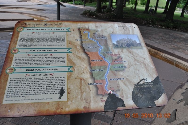
Panel #14 Mississippi Riverwalk
Inscription.
A) Donaldsonville, Louisiana
Mile 175.0 AHP
A trading post was established where Bayou Lafourche met the river in 1750, and a small community grew up around it. Most of the settlers were French, but the town was named for William Donaldson, an Englishman, on whose land the town was laid out in 1806. During the U. S. Civil War, Union boats were fired on from the riverbank at Donaldsonville, and they retaliated by bombarding the town and burning many buildings. U.S. Admiral Farragut threatened to destroy every house there if his boats were bothered again. The local citizens made a public plea to Confederate sympathizers in the area, asking them to leave the Union boats along.
B) Bayou Lafourche
Mile 175.5 AHP
Bayou Lafourche, meaning The Fork, was a narrow outlet of the Mississippi River which carried flood waters into the Gulf. The 110-mile waterway was navigable by steamboats at high water but it also flooded plantations along its banks. In 1903, the mouth of Bayou Lafourche was damned to protect the local farms, and it was permanently closed by the levee system.
C) Geismar, Louisiana
Mile 185.1 AHP
Geismar was part of the “German Coast” on the river above New Orleans, LA. The German farmers who settled in the area were originally lured to Arkansas by promises of a paradise in the New World. When the promises proved empty they headed downriver to find passage home. The French governor, Bienville, persuaded them to settle in Louisiana instead. The Germans proved to be a source of stability in the hard-pressed colony, and the German Coast was widely known for its well organized and profitable small farms. The German people were eventually absorbed into the French population, but the communities kept their German names.
Photo credit: Louisiana Oak Tree with Moss, Louisiana Office of Tourism
Erected by Mississippi Riverwalk. (Marker Number 14.)
Topics. This historical marker is listed in these topic lists: Disasters • Settlements & Settlers • War, US Civil • Waterways & Vessels.
Location. 35° 8.968′ N, 90° 3.507′ W. Marker is in Memphis, Tennessee, in Shelby County. Marker can be reached from Island Drive, 0.8 miles south of West A.W. Willis Avenue. Located in Mud Island River Park. Touch for map. Marker is at or near this postal address: 125 N Front St, Memphis TN 38103, United States of America. Touch for directions.
Other nearby markers. At least 8 other markers are within walking distance of this marker. The Mississippi Riverwalk (here, next to this marker); Ohio River (here, next to this marker); Cairo, Illinois (here, next to this marker); Islands No. 2, 3, and 4 / Fort Jefferson, Kentucky / Bird’s Point, Missouri (here, next to this marker); Island No. 5 (Wolf Island)/Belmont, Missouri/Columbus, Kentucky (here, next to this marker); Donaldson Point, Missouri/Island No. 8/Hickman, Kentucky/Dorena Crevasse (here, next to this marker); New Madrid, Missouri/Cates Casting Field/Island No. 10 (here, next to this marker); Tiptonville, Tennessee/Bixby Towhead (here, next to this marker). Touch for a list and map of all markers in Memphis.
Also see . . .
1. Bayou Lafourche. Bayou Lafourche, originally called Chetimachas River[1] or La Fourche des Chetimaches,[2] (the fork of the Chitimacha), is a 106-mile-long (171 km)[3] bayou in southeastern Louisiana, United States, that flows into the Gulf of Mexico. The bayou is flanked by Louisiana Highway 1 on the west and Louisiana Highway 308 on the east, and is known as "the longest Main Street in the world."[4] It flows through parts of Ascension, Assumption, and Lafourche parishes. Today, approximately 300,000 Louisiana residents drink water drawn from the bayou (Submitted on March 14, 2018, by Sandra Hughes Tidwell of Killen, Alabama, USA.)
2. Geismar, Louisiana. Geismar is an unincorporated community in Ascension Parish, Louisiana, United States and is at the heart of Louisiana's chemical corridor. Geismar is south of Prairieville and west of Gonzales. The community has two schools, Dutchtown Primary/ Middle School and Dutchtown High School, which are ranked among the top schools in the state of Louisiana.[1] The Mississippi River flows to the southeast along the southwest side of the community. The area is vulnerable to hurricanes and tropical systems due to its low elevation and its proximity to the coast of southeast Louisiana. (Submitted on March 14, 2018, by Sandra Hughes Tidwell of Killen, Alabama, USA.)
Credits. This page was last revised on September 24, 2020. It was originally submitted on March 14, 2018, by Sandra Hughes Tidwell of Killen, Alabama, USA. This page has been viewed 454 times since then and 31 times this year. Photo 1. submitted on March 14, 2018, by Sandra Hughes Tidwell of Killen, Alabama, USA. • Bernard Fisher was the editor who published this page.
Editor’s want-list for this marker. Wide shot of marker and its surroundings. • Can you help?
