Near Jeffersonville in Twiggs County, Georgia — The American South (South Atlantic)
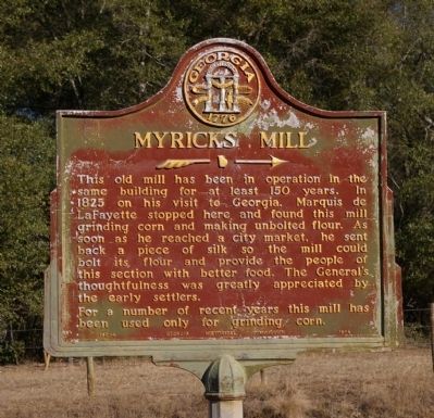
Myricks Mill
For a number of recent years this mill has been used only for grinding corn.
Erected 1954 by Georgia Historical Commission. (Marker Number 143-4.)
Topics and series. This historical marker is listed in these topic lists: Agriculture • Industry & Commerce • Parks & Recreational Areas • Settlements & Settlers. In addition, it is included in the Georgia Historical Society, and the Lafayette’s Farewell Tour series lists. A significant historical year for this entry is 1825.
Location. 32° 47.69′ N, 83° 22.35′ W. Marker is near Jeffersonville, Georgia, in Twiggs County. Marker is on Myricks Mill Road, 0.2 miles south of Hammock Road/Fountain Road, on the left when traveling north. The marker is located at Liberty Hill Church. Touch for map. Marker is in this post office area: Jeffersonville GA 31044, United States of America. Touch for directions.
Other nearby markers. At least 8 other markers are within 7 miles of this marker, measured as the crow flies. Ramah Church (approx. 4.8 miles away); The Stoneman Raid (approx. 6.4 miles away); The Evacuation of Gordon (approx. 6.4 miles away); In Memory of J. Rufus Kelly (approx. 6.4 miles away); The March to the Sea (approx. 6.4 miles away); Gordon Depot-Museum (approx. 6.4 miles away); He Wouldn't Run (approx. 6.4 miles away); Gordon (approx. 6.4 miles away).
Regarding Myricks Mill. The old mill no longer stands, although some of the large timbers from its foundation are still visible at the mill pond.
Unbolted flour is ground wheat that has not been sifted through a bolter. A bolter is cloth or other screen in a frame that is used after grinding to separate out the white flour from the coarse whole wheat.
Credits. This page was last revised on September 19, 2021. It was originally submitted on October 5, 2008, by David Seibert of Sandy Springs, Georgia. This page has been viewed 1,915 times since then and 45 times this year. Photo 1. submitted on October 5, 2008, by David Seibert of Sandy Springs, Georgia. • Bill Pfingsten was the editor who published this page.
Editor’s want-list for this marker. A wide shot of the marker and its surroundings. • Can you help?
