Kinsale
With the Villages of Cove and Scilly
— 1846 —
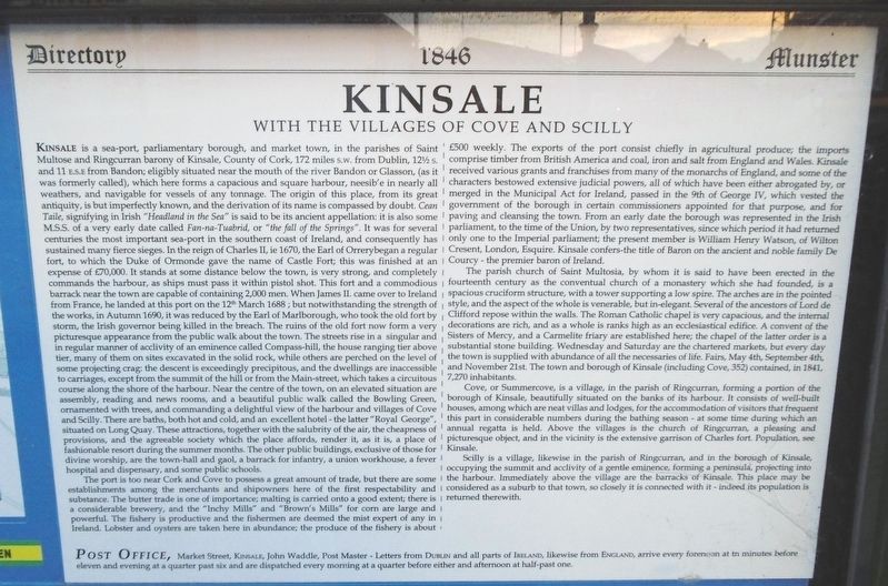
Kinsale is a sea-port, parliamentary borough, and market town, in the parishes of Saint Multose and Ringcurran barony of Kinsale, County of Cork, 172 miles s.w. from Dublin, 12½ s. and 11 e.s.e. from Bandon; eligibly situated near the mouth of the river Bandon or Glasson, (as it was formerly called), which here forms a capacious and square harbour, neesib'e in nearly all weathers, and navigable for vessels of any tonnage. The origin of this place, from its great antiquity, is but imperfectly known, and the derivation of its name is compassed by doubt. Cean Taile, signifying in Irish "Headland in the Sea" is said to be its ancient appellation: it is also some M.S.S. of a very early date called Fan-na-Tuabrid, or "the fall of the Springs". It was for several centuries the most important sea-port in the southern coast of Ireland, and consequently has sustained many fierce sieges. In the reign of Charles II, ie 1670, the Earl of Orrery began a regular fort, to which the Duke of Ormonde gave the name of Castle Fort; this was finished at an expense of £70,000. It stands at some distance below the town, is very strong, and completely commands the harbour, as ships must pass it within pistol shot. This fort and a commodious barrack near the town are capable of containing 2,000 men. When James II. came
over to Ireland from France, he landed at this port on the 12th March 1688; but notwithstanding the strength of the works, in Autumn 1690, it was reduced by the Earl of Marlborough, who took the old fort by storm, the Irish governor being killed in the breach. The ruins of the old fort now form a very picturesque appearance from the public walk about the town. The streets rise in a singular and in regular manner of acclivity of an eminence called Compass-hill, the house ranging tier above tier, many of them on sites excavated in the solid rock, while others are perched on the level of some projecting crag: the descent is exceedingly precipitous, and the dwellings are inaccessible to carriages, except from the summit of the hill or from the Main-street, which takes a circuitous course along the shore of the harbour. Near the centre of the town, on an elevated situation are assembly, reading and news rooms, and a beautiful public walk called the Bowling Green, ornamented with trees, and commanding a delightful view of the harbour and villages of Cove and Scilly. There are baths, both hot and cold, and an excellent hotel-the latter "Royal George", situated on Long Quay. These attractions, together with the salubrity of the air, the cheapness of provisions, and the agreeable society which the place affords, render it, as it is, a place of fashionable resort during the summer months. The other public buildings, exclusive of those for divine worship, are the town-hall and gaol, a barrack for infantry, a union workhouse, a fever hospital and dispensary, and some public schools.The port is too near Cork and Cove to possess a great amount of trade, but there are some establishments among the merchants and shipowners here of the first respectability and substance. The butter trade is one of importance; malting is carried onto a good extent; there is a considerable brewery, and the "Inchy Mills" and "Brown's Mills" for corn are large and powerful. The fishery is productive and the fishermen are deemed the mist [most?] expert of any in Ireland. Lobster and oysters are taken here in abundance; the produce of the fishery is about £500 weekly. The exports of the port consist chiefly in agricultural produce; the imports comprise timber from British America and coal, iron and salt from England and Wales. Kinsale received various grants and franchises from many of the monarchs of England, and some of the characters bestowed extensive judicial powers, all of which have been either abrogated by, or merged in the Municipal Act for Ireland, passed in the 9th of George IV, which vested the government of the borough in certain commissioners appointed for that purpose, and for paving and cleansing the town. From an early date the borough was represented in the Irish
The parish church of Saint Multosia, by whom it is said to have been erected in the fourteenth century as a conventual church of a monastery which she had founded, is a spacious cruciform structure, with a tower supporting a low spire. The arches are in the pointed style, and the aspect of the whole is venerable, but in-elegant. Several of the ancestors of Lord de Clifford repose within the walls. The Roman Catholic chapel is very capacious, and the internal decorations are rich, and as a whole is [it?] ranks high as an ecclesiastical edifice. A convent of the Sisters of Mercy, and a Carmelite friary are established here; the chapel of the latter order is a substantial stone building. Wednesday and Saturday are the chartered markets, but every day the town is supplied with abundance of all the necessaries of life. Fairs, May 4th, September 4th, and November 21st. The town and borough of Kinsale (including Cove, 352) contained, in 1841, 7,270 inhabitants.
Cove, or Summercove, is a village, in the parish of Ringcurran, forming a portion of the borough of
Kinsale, beautifully situated on the banks of its harbour. It consists of well-built houses, among which are near villas and lodges, for the accommodation of visitors that frequent this part in considerable numbers during the bathing season - at some time during which an annual regatta is held. Above the villages is the church of Ringcurran, a pleasing and picturesque object, and in the vicinity is the extensive garrison of Charles fort. Population, see Kinsale.Scilly is a village, likewise in the parish of Ringcurran, and in the borough of Kinsale, occupying the summit and acclivity of a gentle eminence, forming a peninsula, projecting into the harbour. Immediately above the village are the barracks of Kinsale. This place may be considered as a suburb to that town, so closely it is connected with it - indeed its population is returned therewith.
Post Office, Market Street, Kinsale, John Waddle, Post Master - Letters from Dublin and all parts of Ireland, likewise from England, arrive every forenoon at tn [ten?] minutes before eleven and evening at a quarter past six and are dispatched every morning at a quarter before either and afternoon at half-past one.
Recent Discoveries at Market Place
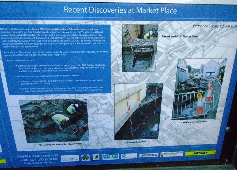
IN RECENT WEEKS works on the Kinsale Main Drainage & Broadband Scheme have uncovered some interesting historical finds. Cork County Council engaged archaeologists from the Youghal based Daniel Noonan Archaeological Consultancy to work as part of the construction team. The archaeologists have discovered, within the confines of the pipeline trench at Market Place, the underground remains of several stone-built structures, along with large stone-built drains and cobble surfaces. The findings were made as part of a programme of ground testing in advance of the main pipeline. Full and detailed excavation has been ongoing for the past few weeks.
Approximately 80 meters of trenches from Market Square to Market Place have been excavated. The trenches average 2.5 meters wide and are sometimes over 3 meters deep.
The discoveries so far include:
• Eight individual parts of mortar-bonded walls, suggesting an earlier 17th Century streetscape beneath Market Place and the surrounding areas. Amongst these are parts of the inner quay wall that once allowed water borne access to the market.
• Seven areas of stone cobbling associated with some of the walls.
• At least ten substantial stone-built culverts that managed the earlier water services in this area from the mid 17th Century.
• Finds of pottery, clay pipes, leather and wood are abundant. The earliest pottery finds date from late 16th Century imported French Saintonge and 17th Century German stonewares.
[Photo captions, clockwise from top center, read]
• Stone Lined Pit at Market Place
• Excavations on Market Place
• Exposed Quay Wall
• Uncovering of Quay Wall at Market Place
Erected by Town of Kinsale, Cork County Council, National Development Plan, et al.
Topics. This historical marker is listed in these topic lists: Man-Made Features • Settlements & Settlers • Waterways & Vessels. A significant historical year for this entry is 1670.
Location. 51° 42.365′ N, 8° 31.494′ W. Marker is in Kinsale, Munster, in County Cork. Marker is at the intersection of Market Square and Guardwell, on the right when traveling east on Market Square. Touch for map. Marker is in this post office area: Kinsale, Munster P17 AF50, Ireland. Touch for directions.
Other nearby markers. At least 8 other markers are within walking distance of this marker. The Town Pound (here, next to this marker); Nautical Artefacts at Kinsale Museum (within shouting distance of this marker); The Pauper's Well / Tobar na mbocht (within shouting distance of this marker); Múseum / Museum (within shouting distance of this marker); Peter Barry (within shouting distance of this marker); The James O'Neill Memorial Building (within shouting distance of this marker); Eaglais Multose Naofa / St. Multose Church (within shouting distance of this marker); Kinsale Town Wall (about 90 meters away, measured in a direct line). Touch for a list and map of all markers in Kinsale.
Also see . . . History of Kinsale. (Submitted on July 29, 2019, by William Fischer, Jr. of Scranton, Pennsylvania.)
Credits. This page was last revised on July 29, 2019. It was originally submitted on July 28, 2019, by William Fischer, Jr. of Scranton, Pennsylvania. This page has been viewed 365 times since then and 44 times this year. Photos: 1, 2, 3. submitted on July 29, 2019, by William Fischer, Jr. of Scranton, Pennsylvania.


