St. Mary's City in St. Mary's County, Maryland — The American Northeast (Mid-Atlantic)
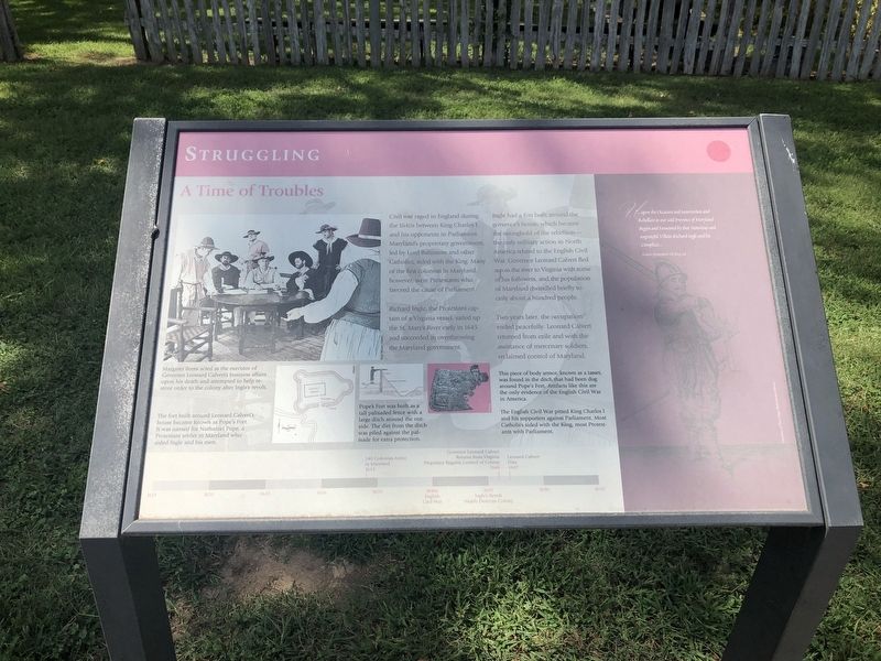
A Time of Troubles
Struggling
Richard Ingle, the Protestant captain of a Virginia vessel, sailed up the St. Mary's River early in 1645 and succeeded in overthrowing the Maryland government.
Ingle had a fort built around the governor's house, which became the stronghold of the rebellion—the only military action in North America related to the English Civil War. Governor Leonard Calvert fled across the river to Virginia with some of his followers, and the population of Maryland dwindled briefly to only about a hundred people.
Two years later, the occupation ended peacefully. Leonard Calvert returned from exile and with the assistance of mercenary soldiers, reclaimed control of Maryland.
[Captions:]
Margaret Brent acted as the executor of Governor Leonard Calvert's business affairs upon his death and attempted to restore order to the colony after Ingle's revolt.
The fort built around Leonard Calvert's house became known as Pope's Fort. It was named for Nathaniel Pope, a Protestant settler in Maryland who aided Ingle and his men.
Pope's fort was built as a tall palisaded fence with a large ditch around the outside. The dirt from the ditch was piled against the palisade for extra protection.
This piece of body armor, known as a tasset, was found in the ditch that had been dug around Pope's Fort. Artifacts like this are the only evidence of the English Civil War in America.
The English Civil War pitted King Charles I and his supporters against Parliament. Most Catholics sided with the King, most Protestants with Parliament.
[Timeline:]
1634 140 Colonists Arrive in Maryland
1640s English Civil War
1645 Ingle's Revolt Nearly Destroys Colony
1646 Governor Leonard Calvert Returns from Virginia
Proprietor Regains Control of Colony
1647 Leonard Calvert Dies
[Aside:]
"...upon the Occasion and insurrection and Rebellion in our said Province of Maryland Begun and fomented by that Notorious and ungrateful Villain Richard Ingle and his Complices...
Archives of Maryland, Vol III, p 236
Erected by Historic St. Mary's City.
Topics. This historical marker is listed in these topic lists: Churches & Religion
Location. 38° 11.065′ N, 76° 25.964′ W. Marker is in St. Mary's City, Maryland, in St. Mary's County. Marker is on Middle Street Path just north of Aldermanbury Street Footpath, on the left when traveling north. Touch for map. Marker is in this post office area: Saint Marys City MD 20686, United States of America. Touch for directions.
Other nearby markers. At least 8 other markers are within walking distance of this marker. Witness to History (within shouting distance of this marker); Early Signs of Industry (within shouting distance of this marker); Horse High, Pig Tight, and Bull Strong (within shouting distance of this marker); Reclaiming the Lost City (within shouting distance of this marker); Layers of the Past (about 300 feet away, measured in a direct line); "…once the Metropolis" (about 300 feet away); From Slavery to Freedom (about 400 feet away); Framing the Past (about 400 feet away). Touch for a list and map of all markers in St. Mary's City.
Credits. This page was last revised on July 20, 2020. It was originally submitted on September 3, 2019, by Devry Becker Jones of Washington, District of Columbia. This page has been viewed 254 times since then and 41 times this year. Photos: 1, 2. submitted on September 3, 2019, by Devry Becker Jones of Washington, District of Columbia.

