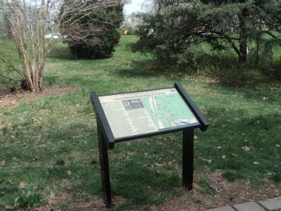
Near Fairfax in Fairfax County, Virginia — The American South (Mid-Atlantic)
General Reno's Probe East of Ox Road
★ The Battle of Ox Hill ★
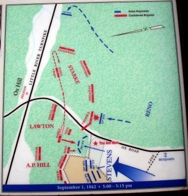
While General Stevens’ division attacked the Confederates on this side of Ox Road, part of General Jesse Reno’s division entered the woods east of the road to protect Stevens’ flank and probe the Confederate line. Reno’s two leading regiments received vague orders to “find the enemy.”
Just before 5 p.m., the 21st Massachusetts stumbled through the darkened woods, their line of battle broken by fallen trees and underbrush. As the thunderstorm erupted, the regiment halted to reform their lines. There was some firing off to their right and a body of troops in dark uniforms stood 25 yards ahead, barely visible.
Some of the men exclaimed, “Those are rebels!” while some thought otherwise. According to Captain Charles Walcott: “While most of our poor fellows stood with their guns at the shoulder, one of the deadliest volleys ever fired rolled upon us from our right and front…the whole regiment seemed to be lying bleeding on the ground…nearly a hundred of our men, dead and wounded, lay there with their officers.”
The Confederates who delivered the fatal volley were probably on the left of Trimble’s brigade of Georgia, North Carolina and Alabama troops, though some shots may have come from Stafford’s Louisiana brigade.
Farther east, near today’s Fair Oaks Mall, the 51st New York encountered part of Starke’s division, probably the Stonewall Brigade, but suffered only minor losses. The 2nd Maryland and 48th Pennsylvania remained in reserve near the unfinished railroad.
Two of Reno’s regiments, the 6th New Hampshire and 51st Pennsylvania, joined the fight west of Ox Road and supported Stevens’ division.
Erected 2008 by Fairfax County Park Authority.
Topics. This historical marker is listed in this topic list: War, US Civil.
Location. 38° 51.878′ N, 77° 22.161′ W. Marker is near Fairfax, Virginia, in Fairfax County. Marker can be reached from West Ox Road (Virginia Route 608). Located at the eighth trail stop wayside at the Ox Hill Battlefield Park Interpretive Trail. Touch for map. Marker is at or near this postal address: 4134 West Ox Road, Fairfax VA 22033, United States of America. Touch for directions.
Other nearby markers. At least 8 other markers are within walking distance of this marker. Aftermath: The Invasion of Maryland (within shouting distance of this marker); The Wounded Left Behind (within shouting distance of this marker); La Batalla de Ox Hill (Chantilly) (within shouting distance of this marker); Who Fought Here: The Generals (within shouting distance of this marker); Where the Battle was Fought (within shouting distance of this marker); Wounds Suffered at Ox Hill (Chantilly) (within shouting distance of this marker); Sequel to Second Manassas (within shouting distance of this marker); Ox Hill Battlefield Park & Interpretive Trail (within shouting distance of this marker). Touch for a list and map of all markers in Fairfax.
More about this marker. The upper middle of the marker features a sketch captioned, “Sketch of Union troops at Glendale, Virginia, by A.R. Waud. This battle scene in the woods is probably similar to the scene at Ox Hill where the 21st Massachusetts was nearly slaughtered.” Courtesy of The Library of Congress. On the right side of the marker is a battle map.
Also see . . . The Battle of Chantilly. Civil War Preservation Trust (Submitted on January 10, 2009.)
Credits. This page was last revised on September 23, 2021. It was originally submitted on January 10, 2009. This page has been viewed 1,340 times since then and 23 times this year. Last updated on September 21, 2021. Photos: 1. submitted on January 10, 2009. 2. submitted on April 18, 2014, by Bill Coughlin of Woodland Park, New Jersey. 3, 4. submitted on January 10, 2009. • J. Makali Bruton was the editor who published this page.


