Marker Logo HMdb.org THE HISTORICAL
MARKER DATABASE
“Bite-Size Bits of Local, National, and Global History”
Kit Carson in Amador County, California — The American West (Pacific Coastal)
 

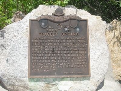
Tragedy Spring

No 338

— Erected 1967 —


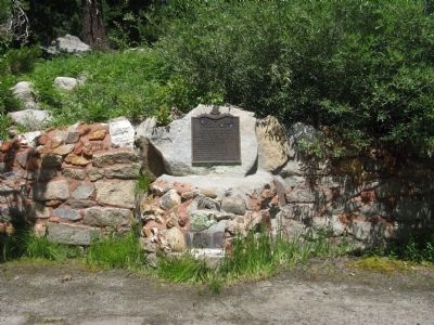
Tragedy Spring Marker image. Click for full size.
Photographed By Syd Whittle, July 26, 2009
1. Tragedy Spring Marker
Inscription. This campsite on the Kit Carson Emigrant Trail was a resting place for California settlers. It was named by members of the Mormon Battalion enroute to Salt Lake Valley. Three of their men, serving as advance trail scouts, were murdered here by unknown persons June 27, 1848. Battalion friends, arriving a few days later, buried them in a common grave and carved their names (Henderson Cox, Ezra Allen, Daniel Browett) on a nearby tree, thus preserving the grave’s location.
 
Erected 1967 by Daughters of Utah Pioneers, Sacramento County. (Marker Number 338.)
 
Topics and series. This historical marker is listed in these topic lists: ExplorationNotable PlacesRoads & Vehicles. In addition, it is included in the Daughters of Utah Pioneers, and the Mormon Battalion series lists. A significant historical date for this entry is June 27, 1862.
 
Location. 38° 38.364′ N, 120° 8.817′ W. Marker is in Kit Carson, California, in Amador County. Marker is on Tragedy Springs Road near Carson Pass Scenic Byway (California Highway 88). Gravesite and additional markers are located a short hike from the main marker. Touch for map. Marker is in this post office area: Kit Carson CA 95644, United States of America. Touch for directions.
 
Other nearby markers. At least 8 other markers are within 7 miles of this marker, measured as the crow flies. Old Emigrant Road (approx. 0.3 miles away); Mormon-Carson Pass Emigrant Trail
Paid Advertisement
Click on the ad for more information.
Please report objectionable advertising to the Editor.
Click or scan to see
this page online
(approx. 0.6 miles away); Plasse Resort (approx. 1.1 miles away); Plasse’s Trading Post (approx. 1.1 miles away); Maiden's Grave (approx. 1.4 miles away); Carson Trail - Leek Springs (approx. 5 miles away); Kirkwood's (approx. 5.9 miles away); Caples Lake (approx. 6.6 miles away). Touch for a list and map of all markers in Kit Carson.
 
Additional keywords. Mormon Emigrant Trail
 
Tragedy Spring Marker image. Click for full size.
Photographed By Syd Whittle, July 26, 2009
2. Tragedy Spring Marker
Sign at Beginning of Trail to the Gravesite. image. Click for full size.
Photographed By Syd Whittle, July 26, 2009
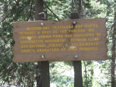
3. Sign at Beginning of Trail to the Gravesite.
Modern day travelers are invited to pause & rest as the pioneers did. Tragedy Spring Park was developed by cooperative agreement El Dorado National Forest & Sacramento County, Daughters of Utah Pioneers.
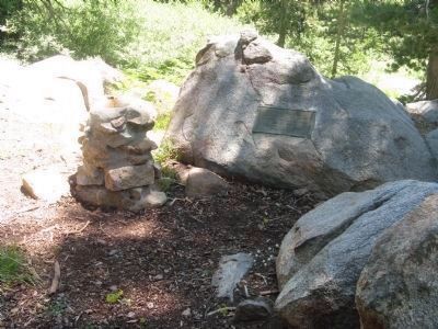
Fountain on the Trail to the Gravesite image. Click for full size.
Photographed By Syd Whittle, July 26, 2009
4. Fountain on the Trail to the Gravesite
Plaque reads:
Fountain erected in memory of the three Mormon Battalion men buried here
Plaque placed by the Sons of Utah Pioneers, September 2, 1967.
Interpretive Sign at the Gravesite image. Click for full size.
Photographed By Syd Whittle, July 26, 2009
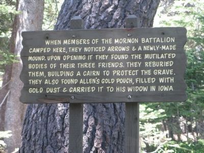
5. Interpretive Sign at the Gravesite
When members of the Mormon Battalion camped here, they noticed arrows & a newly-made mound. Upon opening it they found the mutilated bodies of their three friends. They reburied them, building a cairn to protect the grave. They also found Allen’s gold pouch, filled with gold dust & carried it to his widow in Iowa.
Plaque - Granite Rock Displaying Replica of Tree Carving image. Click for full size.
Photographed By Syd Whittle, July 26, 2009
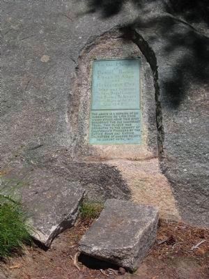
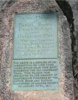
6. Plaque - Granite Rock Displaying Replica of Tree Carving
Plaque Embedded in Granite Rock Near Gravesite image. Click for full size.
Photographed By Syd Whittle, July 26, 2009
7. Plaque Embedded in Granite Rock Near Gravesite
To the Memory
of
Daniel Browett
Ezrah H. Allen
And
Henderson Cox
Who was supposed
To have Been Murdered
And Burned By Indians
On the Night of the 27 Of
June 1848
______________
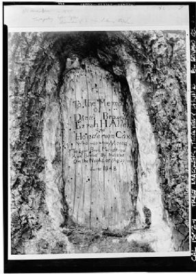
The above is a replica of an inscription on a fir tree which stood near this spot bordering the Old Immigrant Trail. This plaque was dedicated to the memory of California's Pioneers by the Native Daughters of Amador County on August 30th, 1931.
Original Tree Carving image. Click for more information.
Photographed By Habs-loc
8. Original Tree Carving
This photo of the actual carving is a 1940 re-photo of an original held in the collection of the Sacramento Chamber of Commerce.
HABS CAL,9-TRAG,1-
Click for more information.
Plaque at Gravesite image. Click for full size.
Photographed By Syd Whittle, July 26, 2009
9. Plaque at Gravesite
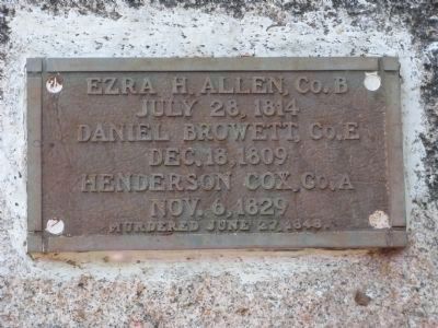
Ezra H. Allen, Co.B
July 28, 1814
Daniel Browett, Co.E
Dec. 18, 1809
Henderson Cox, Co.A
Nov. 6, 1829
Murdered June 27, 1848
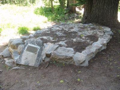
Gravesite of Henderson Cox, Ezra Allen and Daniel Browett image. Click for full size.
Photographed By Syd Whittle, July 26, 2009
10. Gravesite of Henderson Cox, Ezra Allen and Daniel Browett
 
 
Credits. This page was last revised on June 16, 2016. It was originally submitted on July 31, 2009, by Syd Whittle of Mesa, Arizona. This page has been viewed 6,975 times since then and 91 times this year. Photos:   1, 2, 3, 4, 5, 6, 7. submitted on July 31, 2009, by Syd Whittle of Mesa, Arizona.   8. submitted on November 16, 2009, by Syd Whittle of Mesa, Arizona.   9, 10. submitted on July 31, 2009, by Syd Whittle of Mesa, Arizona.
Share this page.  
Share on Tumblr
m=21273

CeraNet Cloud Computing sponsors the Historical Marker Database.
This website earns income from purchases you make after using our links to Amazon.com. We appreciate your support.
Paid Advertisement
Apr. 23, 2024