Poughkeepsie in Dutchess County, New York — The American Northeast (Mid-Atlantic)
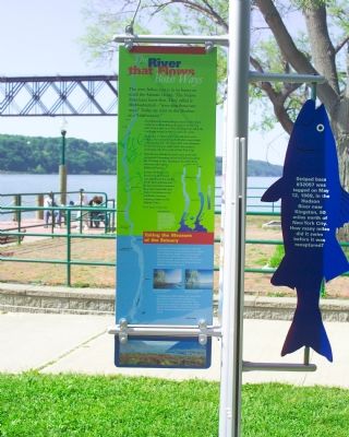
River That Flows Both Ways
The Hudsonís current changes direction four times every day as ocean tides pulse upriver to the Troy dam. Drop a stick in at Troy. Drifting back and forth, it will take several months to reach the ocean.
An estuary is a place where salt and fresh water mingle. Seawater entering the Hudson meets fresh water flowing from the upper river and tributaries. In the summer, you might taste a bit of salt in Newburgh, 60 miles north of New York City.
Estuaries are among the earthís most productive ecosystems. Swimming below the Hudsonís surface are 200 kinds of fish. Feasting on its riches from above are bald eagles, ducks, and herons.
Sewage discharges and destruction of wetlands once threatened this wealth of life. Anti-pollution and habitat protection measures have since turned the tide. Today the Hudson is the healthiest, most awe-inspiring estuary on the Atlantic Coast.
Let's keep it that way.
Taking the Measure of the Estuary
The Hudson flows 315 miles from Lake Tear of the Clouds in the Adirondacks to the Upper Bay of New York Harbor. It is an estuary for the 153 miles from Troy to the Bay, which extends another seven miles to the Narrows and the Verrazano-Narrows Bridge between Brooklyn and Staten Island.
The Hudsonís width ranges from about 500 feet at Troy to three and a half miles at Haverstraw. It is deepest at West Point—216 feet according to a 1934 survey. Depths change with the tides; water levels at high tide are three to five feet above the low tide levels.
(Text of Adjacent fish-shaped marker) Striped bass #32057 was tagged on May 12, 1989 in the Hudson River near Kingston, 90 miles north of New York City. ē How many miles did it swim before it was recaptured?
Topics. This historical marker is listed in these topic lists: Environment • Natural Features • Natural Resources. A significant historical month for this entry is May 1743.
Location. 41° 42.385′ N, 73° 56.423′ W. Marker is in Poughkeepsie, New York, in Dutchess County. Marker can be reached from Water Street near Main Street. Markers are on the shore of the Hudson River in the Victor Waryas Park. The park is adjacent to the Poughkeepsie train station. Touch for map. Marker is in this post office area: Poughkeepsie NY 12601, United States of America. Touch for directions.
Other nearby markers. At least 8 other markers are within walking distance of this marker. Victor C. Waryas Memorial Park (within shouting distance of this marker); The Queen City of the Hudson (about 600 feet away, measured in a direct line); Walkway Over the Hudson (about 600 feet away); Walkway Loop Trail (about 600 feet away); Poughkeepsie Waterfront (approx. 0.2 miles away); Union Street Historic Neighborhood (approx. ľ mile away); Little Italy (approx. ľ mile away); Lange Rack (approx. 0.3 miles away). Touch for a list and map of all markers in Poughkeepsie.
Credits. This page was last revised on June 16, 2016. It was originally submitted on September 13, 2007, by Tom Fuchs of Greenbelt, Maryland. This page has been viewed 4,567 times since then and 19 times this year. Photos: 1, 2, 3. submitted on September 13, 2007, by Tom Fuchs of Greenbelt, Maryland. • J. J. Prats was the editor who published this page.


