Toms Brook in Shenandoah County, Virginia — The American South (Mid-Atlantic)
Toms Brook
Sunday, October 9th
— 1864 Valley Campaign —
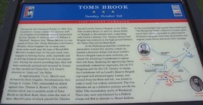
During the evening of October 8, 1864, Gen. Lunsford L. Lomax reached this position with two brigades of Confederate cavalry commanded by Gen. Bradley T. Johnson and Col. William L. "Mudwall" Jackson. Gen. Wesley Merritt, in command of the Union Gen. Philip Sheridan's 1st Cavalry Division (three brigades) lay in camp some three miles north near the base of Round Hill. Merritt's troopers had, for the past week, been engaged in burning barns, mills, haystacks and driving livestock seized from the local population. During the several preceding days, they had been cautiously pursued and harassed by Lomax as they carried out Union Gen. U.S. Grant's directive to "clean out" the Valley.
At approximately 7 a.m., Merritt sent forward his three brigades. Simultaneously, Gen. George A. Custer, USA, commanded an attack against Gen. Thomas A. Rosser's, CSA, cavalry division which was in position south of Toms Brook on the Back Road, three miles due west of here. Merritt's plan of attack placed Col. Charles Russell Lowell's Reserve Brigade on the Valley Pike (modern Route 11) and Col. James Kidd's 1st Brigade to the extreme west, cooperating with Custer's advance. Col. Thomas Devin's 2nd Brigade was centered on the high ground between the Valley Pike and the Back Road.
As the Federals pressed the Confederate skirmishers toward this vicinity, Lomax unleashed a ferocious charge that drove Lowell's Reserve Brigade back in some confusion, yet caused the advancing Confederates to expose their left flank. Realizing the opportunity, Devin immediately ordered two regiments, the 1st N.Y. Dragoons and the 5th U.S. Cavalry, to charge the Confederate left as Lowell's Reserve Brigade regrouped and advanced again. Lomax, now pressed from the front and left, was forced to make a hasty but orderly withdrawal. The Confederates set up a defensive position astride the Valley Pike immediately north of Woodstock. There they were overwhelmed by a Federal Charge and fled in disorder to Mount Jackson. In the running fight that ensued (later nicknamed "The Woodstock Races"), Merritt's troopers, glorious in their victory, succeeded in capturing five of Lomax's six guns, more than 50 prisoners and wagons, many horses and much other equipage.
Erected by Civil War Trails.
Topics and series. This historical marker is listed in this topic list: War, US Civil. In addition, it is included in the Former U.S. Presidents: #18 Ulysses S. Grant, and the Virginia Civil War Trails series lists. A significant historical date for this entry is October 9, 1960.
Location. 38° 56.035′ N, 78° 27.403′ W. Marker is in Toms Brook, Virginia, in Shenandoah County. Marker can be reached from Park Lane. Located inside Shenandoah County Park near Maurertown, at the end of the park access road. Parking closest to the trail leading to the marker is behind the tennis courts. Touch for map. Marker is in this post office area: Toms Brook VA 22660, United States of America. Touch for directions.
Other nearby markers. At least 8 other markers are within 5 miles of this marker, measured as the crow flies. Shenandoah County Farm and Alms House (approx. 0.2 miles away); a different marker also named Toms Brook (approx. ¼ mile away); Action of Toms Brook (approx. 0.8 miles away); "Snapp House" (approx. 3.2 miles away); Battle of Fisher's Hill (approx. 3.3 miles away); a different marker also named Battle of Fisher's Hill (approx. 4 miles away); Woodstock (approx. 4 miles away); a different marker also named Battle of Fisher's Hill (approx. 4.1 miles away).
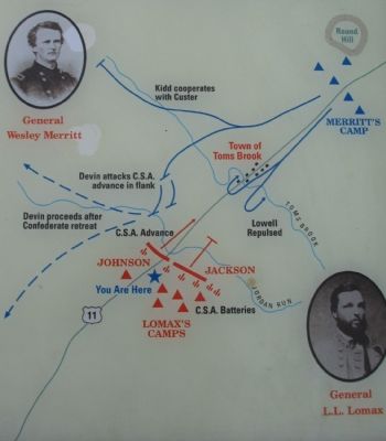
More about this marker. The marker displays a map illustrating the action described in the text. The map has portraits of Gens. Merritt and Lomax at the corners.
Related markers. Click here for a list of markers that are related to this marker. To better understand the relationship, study each marker in the order shown.

Photographed By Craig Swain, October 7, 2007
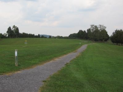
3. Toms Brook Marker Location
This Virginia Civil War Trails marker is reached quite literally at the end of a trail. The white square in the far distance on the treeline is the marker. The ground around the trail was Gen. Lomax's position, with artillery pieces placed upon the ridge line near the marker. Round Hill stands in the distant center, beyond the treeline.

Photographed By Craig Swain, October 7, 2007
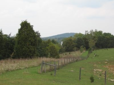
4. Toms Brook Marker
Lomax initially deployed his men in this vicinity. After the attack of Lowell's Federals, Lomax advanced towards Jordon Run, past the treeline in the background. There they were flanked and withdrew.
All around the walking trail to this marker are cow pastures, reminding the visitor of the strategic objective of the Federal army during this campaign - the agricultural resources of the Valley.
All around the walking trail to this marker are cow pastures, reminding the visitor of the strategic objective of the Federal army during this campaign - the agricultural resources of the Valley.
Credits. This page was last revised on September 24, 2021. It was originally submitted on October 13, 2007, by Craig Swain of Leesburg, Virginia. This page has been viewed 3,302 times since then and 81 times this year. Last updated on September 23, 2021, by Bradley Owen of Morgantown, West Virginia. Photos: 1, 2, 3, 4, 5. submitted on October 13, 2007, by Craig Swain of Leesburg, Virginia. • J. Makali Bruton was the editor who published this page.


