Pulaski in Giles County, Tennessee — The American South (East South Central)
The Bell Route
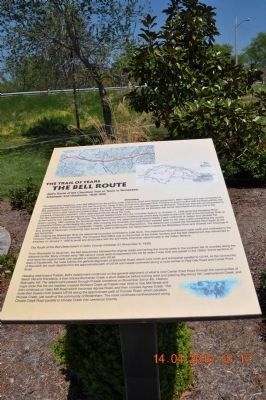
The Trail of Tears
The detachment headed by John Bell differed from the parties under Cherokee Chief John Ross's supervision. Bell's detachment was composed of approximately 650-700 Cherokee who had favored the Treaty of New Echota and opposed Ross. Possibly to avoid conflict with the Ross parties, the Bell detachment opted for a more direct route to the Indian Territory through southern Tennessee via Memphis. The group was also accompanied by a military escort under Lieutenant Edward Deas. The route of the Bell detachment can be followed with some reasonable accuracy due to the existence of payment vouchers, which detail expenditures along the route. The Bell detachment with 56 wagons and 318 horses headed south from the Cherokee Agency on October 11, 1838 along the Hiawassee River toward what is now Cleveland, Tennessee. The detachment traveled to Chattanooga where they crossed to the north side of the Tennessee River at Ross's Landing.
After crossing the Tennessee River twice more, the detachment traveled to Battle Creek northwest of Jasper and climbed the Cumberland Plateau at Monteagle Mountain. After crossing the mountain, the detachment crossed the Tennessee River again at the seat communities of Winchester, Fayetteville, Pulaski, Lawrenceburg and Waynesboro.
The detachment crossed the Tennessee River again at the ferry landing at Savannah. Continuing west across the state to Memphis, the detachment crossed the Mississippi River and entered into Arkansas in late November.
After crossing the Mississippi River the detachment traveled northwest to Little Rock. The detachment then followed roads north and northwest to the Vineyard Post Office (now Evansville). The Vineyard Post Office was on the border of the Indian Territory and the Bell detachment was disbanded in Arkansas on January 7, 1839 to avoid any encounters with the anti-treaty Cherokee detachments in the Indian Territory.
The Route of the Bell Detachment in Giles County (October 31-November 5, 1838)
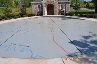
From Winchester to Savannah, the Bell detachment followed the original roads connecting the county seats in the southern tier of counties along the Alabama border. Many of these early 19th century roads were incorporated into US 64 when it was built and paved in the 1920s. Some sections of what were the original roads now parallel or intersect with US 64. West of Fayetteville, the route follows the general alignment of Boonshill Road, which runs north and somewhat parallel to US 64. At the community of Boonshill, the route departs from the approximate path of US 64 and heads northwest along a route similar to
Red Oak Road and Center Point Road.
Heading west toward Pulaski, Bell's detachment continued on the general alignment of what is now Center Point Road through the communities of Beech Hill and Friendship. It then follows Buchanan Creek a short distance before turning west and passing Big Henry Hill, Leatherwood Creek and Abernathy Hill. The detachment passed through Pulaski sometime on November 3rd or 4th. Historic maps show that the old roadbed crossed Richland Creek at Pulaski near what is now Mill Street and then continues on Vales Mill Road which becomes Agnew Road, and then crosses Agnew Creek. The route then travels north toward US 64 along the approximate path of Puryear Road, which parallels Puryear Creek, just south of the community of Bodenham. The route continues northwestward along Choate Creek Road parallel to Choate Creek into Lawrence County.
Topics and series. This historical marker is listed in these topic lists: Native Americans • Notable Events • Notable Places. In addition, it is included in the Trail of Tears series list. A significant historical month for this entry is January 1863.
Location. 35° 11.746′ N, 87° 1.801′ W. Marker is in Pulaski, Tennessee, in Giles County. Marker is on Stadium Street near East College Street (U.S. 64). Located in front of the Trail of Tears Interpretive Center. Touch for map. Marker is in this post office area: Pulaski TN 38478, United States of America. Touch for directions.
Other nearby markers. At least 8 other markers are within walking distance of this marker. The Trail of Tears Interpretive Center (a few steps from this marker); Giles County Trail of Tears Memorial (a few steps from this marker); The Benge Route (within shouting distance of this marker); Nunahi-Duna-Dlo-Hily-I (within shouting distance of this marker); Trail of Tears (within shouting distance of this marker); Giles County Courthouses (about 400 feet away, measured in a direct line); Count Casimir Pulaski (1747-1779) (about 400 feet away); Native Americans in Giles County (about 400 feet away). Touch for a list and map of all markers in Pulaski.
Additional commentary.
1. The Bell Route
The Hiwassee River runs east and west. When the Bell Party left Fort Cass (Charleston, TN) they traveled south away from the river. All of the other groups left Fort Cass and followed the Hiwassee River west to Blythe's Ferry.
— Submitted September 29, 2010, by Debbie Moore of Cleveland, Tennessee.
Credits. This page was last revised on June 16, 2016. It was originally submitted on April 15, 2010, by Sandra Hughes Tidwell of Killen, Alabama, USA. This page has been viewed 3,068 times since then and 123 times this year. Photos: 1, 2, 3. submitted on April 15, 2010, by Sandra Hughes Tidwell of Killen, Alabama, USA. • Kevin W. was the editor who published this page.


