Fort Scott in Bourbon County, Kansas — The American Midwest (Upper Plains)
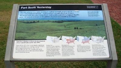
Fort Scott Yesterday
"The site selected is a ridge seventy or eighty feet high projecting like a wedge into a dry timbered bottom....A fine stream of water flows at its base....We designated [the site] Camp Scott, and would respectfully suggest that the post...be named in honor of the gallant General Commanding in Chief."
B.D. Moore, Captain, 1st Dragoons, April 14, 1842, describing his selection of the site that would become Fort Scott, and the suggestion to name it to honor General Winfield Scott.
Fort Scott's history reflects the development of the United States in the mid-1800s.
From 1842 to 1873, Fort Scott played a significant part in events that were shaping a young America into a transcontinental power. Fort Scott National Historic Site was established in 1978 to commemorate Fort Scott's role in four distinct eras of American history.
Frontier Fort
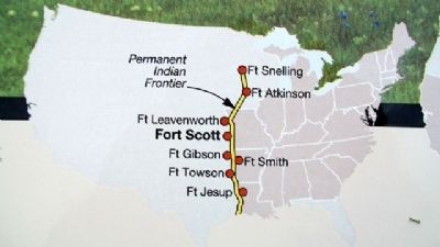
In 1842 the U.S. Army established Fort Scott as a link in a chain of forts that stretched from Minnesota to Louisiana. The forts were intended to guard the "Permanent Indian Frontier." From 1842 until 1853 soldiers from Fort Scott patrolled the plains, policed overland trails, and contacted Indian tribes. In 1846 the army sent troops from Fort Scott to the Mexican War.
Bleeding Kansas
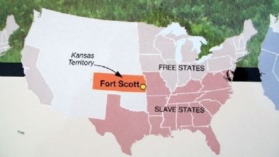
Eastern Kansas witnessed violent clashes between pro- and anti-slavery forces in the late 1850s. Fort Scott (no longer a fort but now a town) was not spared. Frequent turmoil prompted the army's periodic return to restore order. Resolution of the slavery issue finally came when Kansas entered the Union as a free state on January 29, 1861.
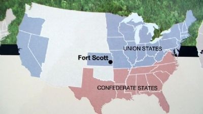
Civil War
With the onset of the Civil War, the Union Army selected the Fort Scott area for a supply base and training ground. Extensive Union facilities here supported operations in Kansas, Missouri, Arkansas, and the Indian Territory (Oklahoma).
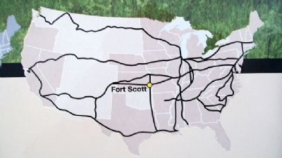
Expanding Railroads
Railroads opened the West; four lines reached the Pacific by 1885. Many other lines connected through towns like Fort Scott, but not without dispute. The army operated the "Post of Southeast Kansas" in Fort Scott from 1869 to 1873 to protect the railroads. Soldiers guarded construction workers from attack by landholders trying to stop the rails from crossing their property.
[Photo caption reads]
This photo of open prairie dropping down to a timber-lined drainage might resemble the scene viewed here by Captain Moore in 1842, when he chose the site for Fort Scott. The photo was taken at Tallgrass Prairie National Preserve, about 100 miles west of here.
Erected 1998 by National Park Service.
Topics and series. This historical marker
is listed in these topic lists: Environment • Forts and Castles • Settlements & Settlers • War, US Civil. In addition, it is included in the Fort Scott, Kansas series list. A significant historical month for this entry is January 1865.
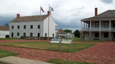
Location. 37° 50.579′ N, 94° 42.334′ W. Marker is in Fort Scott, Kansas, in Bourbon County. Marker can be reached from Old Fort Boulevard. Marker is on the grounds of Fort Scott National Historical Site. Touch for map. Marker is in this post office area: Fort Scott KS 66701, United States of America. Touch for directions.
Other nearby markers. At least 8 other markers are within walking distance of this marker. Civil War Town (a few steps from this marker); The Sites and People of Fort Scott (a few steps from this marker); Fort Scott (a few steps from this marker); Gordon Parks (a few steps from this marker); Sutler Store (within shouting distance of this marker); Fort Gardens (within shouting distance of this marker); Medal of Honor (within shouting distance of this marker); "A Most Deplorable Condition" (within shouting distance of this marker). Touch for a list and map of all markers in Fort Scott.
Also see . . . Fort Scott National Historic Site. (Submitted on September 29, 2010, by William Fischer, Jr. of Scranton, Pennsylvania.)
Credits. This page was last revised on June 16, 2016. It was originally submitted on September 29, 2010, by William Fischer, Jr. of Scranton, Pennsylvania. This page has been viewed 1,272 times since then and 13 times this year. Photos: 1, 2, 3, 4, 5, 6. submitted on September 29, 2010, by William Fischer, Jr. of Scranton, Pennsylvania.
