Near Elfrida in Cochise County, Arizona — The American Mountains (Southwest)
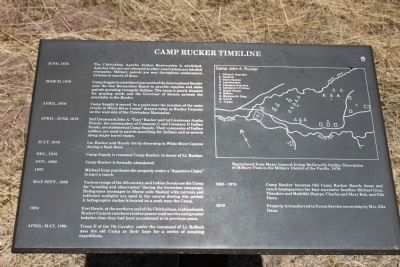
Camp Rucker Timeline
June, 1876 - The Chiricahua Apache Indian Reservation is abolished. Apaches who are not relocated to other reservations are labeled renegades. Military patrols are sent throughout southeastern Arizona in search of them.
March, 1878 - Camp Supply is established just north of the International Border near San Bernardino Ranch to provide supplies and assist patrols pursuing renegade Indians. The camp is poorly situated for grazing needs and the Governor of Sonora protests the proximity to the Border.
April, 1878 - Camp Supply is moved “to a point near the junction of the main creeks in White River Canon” (known today as Rucker Canyon) on the west side of the Chiriccahua Mountains.
April – June, 1878 - 2nd Lieutenant John A. “Tony” Rucker and 1st Lieutenant Austin Henely, the commanders of Company C and Company D Indian Scouts, are stationed at Camp Supply. Their companies of Indian soldiers are used in patrols searching for Indians and as escorts along major travel routes.
July, 1878 - Lts. Rucker and Henely die by drowning in White River Canyon during a flash flood.
Dec., 1878 - Camp Supply is renamed Camp Rucker, in honor of Lt. Rucker.
Nov., 1880 - Camp Rucker is formally abandoned.
1883 - Michael Gray purchases the property under a “Squatters Claim” to start a ranch.
May-Sept., 1886 - Various troops of the 4th cavalry and Indian Scouts use the Camp for “scouting and observation” during the Geronimo campaign. Heliograms (messages in Morse code flashed with mirrors and reflected sunlight) are used in the canyon during this period. A heliographic station is located on a peak near the Camp.
1894 - Fort Bowie, at the northern end of the Chiricahuas, is abandoned. Rucker Canyon ranchers receive poorer mail service and greater isolation than they had been accustomed to in previous years.
April –May, 1896 - Troop E of the 7th Cavalry under the command of Lt. Bullock used the old Camp as their base for a series of scouting expeditions.
1883 – 1970 - Camp Rucker becomes Old Camp Rucker Ranch, home and ranch headquarters for four successive families: Michael Gray, Theodore and Mathilde Hampe, Charles and Mary Rak, and Ella Dana.
1970 - Property is transferred to Forest Service ownership by Mrs. Ella Dana.
Erected by United States Forest Service.
Topics. This historical marker is listed in these topic lists: Forts and Castles • Native Americans • Settlements & Settlers • Wars, US Indian. A significant historical month for this entry is March 1878.
Location. 31° 45.231′ N, 109° 21.535′ W. Marker is near Elfrida, Arizona, in Cochise County. Marker can be reached from North Tex Canyon Road near East Rucker Canyon Road. Touch for map. Marker is in this post office area: Elfrida AZ 85610, United States of America. Touch for directions.
Other nearby markers. At least 6 other markers are within 9 miles of this marker, measured as the crow flies. How Camp Rucker received its Name (within shouting distance of this marker); Camp John A. Rucker A Military Outpost (within shouting distance of this marker); Old Camp Rucker Ranch (within shouting distance of this marker); Camp Rucker and the Indian Scouts (within shouting distance of this marker); Camp Rucker Bakery and Commissary (about 300 feet away, measured in a direct line); John Ringo (approx. 8˝ miles away).
Additional keywords. forced relocation
Credits. This page was last revised on June 6, 2020. It was originally submitted on May 1, 2011, by James Nuti of Bisbee, Arizona. This page has been viewed 1,099 times since then and 24 times this year. Photos: 1. submitted on April 30, 2011, by James Nuti of Bisbee, Arizona. 2. submitted on February 1, 2012, by James Nuti of Bisbee, Arizona. 3. submitted on June 6, 2020, by Bill Kirchner of Tucson, Arizona. • Syd Whittle was the editor who published this page.


