Boerne in Kendall County, Texas — The American South (West South Central)
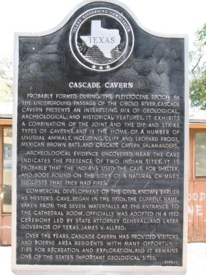
Cascade Cavern
Archeological evidence uncovered near the cave indicates the presence of two Indian sites. It is probable that the Indians used the cave for shelter, and soot found on the sides of a natural chimney suggests that they had fires.
Commercial development of the cave, known earlier as Hester's Cave, began in the 1930s. The current name, taken from the seven waterfalls at the entrance to the cathedral room, officially was adopted in a 1932 ceremony led by State Attorney General, and later governor of Texas, James V. Allred.
Over the years, Cascade Cavern has provided visitors and Boerne area residents with many opportunities for recreation and exploration, and it remains one of the state's important geological sites.
Erected 1984 by Texas Historical Commission. (Marker Number 749.)
Topics. This historical marker is listed in these topic lists: Anthropology & Archaeology • Entertainment • Native Americans • Paleontology. A significant historical year for this entry is 1932.
Location. 29° 45.823′ N, 98° 40.78′ W. Marker is in Boerne, Texas, in Kendall County. Marker can be reached from Cascade Caverns Road, 0.8 miles north of Scheele Road. Touch for map. Marker is in this post office area: Boerne TX 78006, United States of America. Touch for directions.
Other nearby markers. At least 8 other markers are within 4 miles of this marker, measured as the crow flies. Pinta Trail in Kendall County (approx. 2.4 miles away); Dr. Ferdinand Ludwig von Herff (approx. 2.4 miles away); James House (approx. 3.2 miles away); Boerne (approx. 3.3 miles away); US Army Spc. James M. Kiehl (approx. 3.3 miles away); US Army Private First Class Milton A. Lee (approx. 3.3 miles away); US Air Force Captain Mark "Tyler" Voss (approx. 3.3 miles away); Veterans Plaza Vietnam War Memorial (approx. 3.3 miles away). Touch for a list and map of all markers in Boerne.
Related markers. Click here for a list of markers that are related to this marker. To better understand the relationship, study each marker in the order shown.
Also see . . . Pinta Trail, Handbook of Texas Online. Texas State Historical Association (Submitted on September 7, 2011, by Richard Denney of Austin, Texas.)
Credits. This page was last revised on June 16, 2016. It was originally submitted on September 7, 2011, by Richard Denney of Austin, Texas. This page has been viewed 1,147 times since then and 35 times this year. Photos: 1, 2. submitted on September 7, 2011, by Richard Denney of Austin, Texas. • Bernard Fisher was the editor who published this page.

