Thomaston in Knox County, Maine — The American Northeast (New England)
The Voyage of Captain George Waymouth
Inscription.
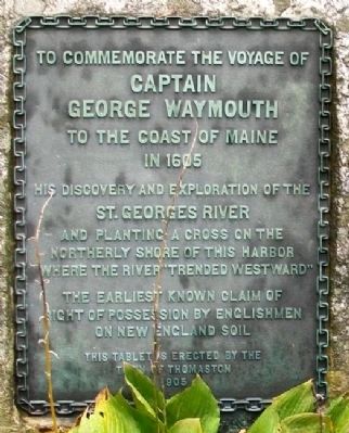
Captain George Waymouth
to the Coast of Maine
in 1605
His discovery and exploration of the
St. Georges River
and planting a Cross on the
northerly shore of this harbor
where the river "trended westward"
The earliest known claim of
right of possession by Englishmen
on New England soil
Erected 1905 by Town of Thomaston.
Topics. This historical marker is listed in these topic lists: Colonial Era • Exploration • Waterways & Vessels. A significant historical year for this entry is 1605.
Location. 44° 4.688′ N, 69° 11.21′ W. Marker is in Thomaston, Maine, in Knox County. Marker is on City Avenue / Main Street, on the left when traveling west. Marker is in a small park west of downtown. Touch for map. Marker is in this post office area: Thomaston ME 04861, United States of America. Touch for directions.
Other nearby markers. At least 8 other markers are within walking distance of this marker. Civil War Soldiers and Sailors Memorial (within shouting distance of this marker); War Memorial (within shouting distance of this marker); Thomaston Historical Timeline (approx. 0.2 miles away); Near the Old Prison / À Coté de l'Ancienne Prison (approx. 0.2 miles away); The Builders, the Captains and the Seamen of Thomaston Ships (approx. 0.2 miles away); Thomaston, Maine (approx. 0.2 miles away); Maine State Prison (approx. ¼ mile away); Former State Prison Site (approx. ¼ mile away). Touch for a list and map of all markers in Thomaston.
Also see . . .
1. Rosier's True Relation of Waymouth's Voyage, published 1605. American Journies website entry (Submitted on April 20, 2012, by William Fischer, Jr. of Scranton, Pennsylvania.)
2. George Waymouth. Wikipedia entry (Submitted on April 3, 2021, by Larry Gertner of New York, New York.)
Credits. This page was last revised on July 1, 2023. It was originally submitted on April 20, 2012, by William Fischer, Jr. of Scranton, Pennsylvania. This page has been viewed 815 times since then and 36 times this year. Photos: 1, 2. submitted on April 20, 2012, by William Fischer, Jr. of Scranton, Pennsylvania. 3. submitted on April 3, 2021, by Larry Gertner of New York, New York.


