Riverside in Platte County, Missouri — The American Midwest (Upper Plains)
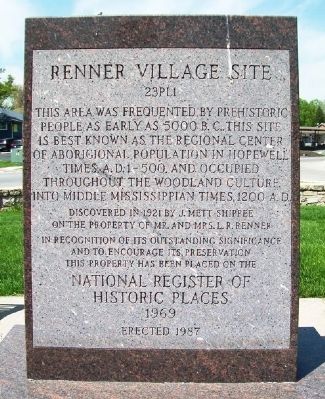
Renner Village Site
23PL1
This area was frequented by prehistoric people as early as 5000 B.C.. This site is best known as the regional center of aboriginal population in Hopewell times, A.D. 1-500, and occupied throughout the Woodland Culture into Middle Mississippian times, 1200 A.D.
Discovered in 1921 by J. Mett Shippee on the property of Mr. and Mrs. L. R. Renner
In recognition of its outstanding significance and to encourage its preservation this property has been placed on the National Register of Historic Places 1969
(Back)
"Remove not the ancient landmark thy fathers have set."
Proverbs 22:28
Erected 1987.
Topics. This historical marker is listed in these topic lists: Anthropology & Archaeology • Native Americans.
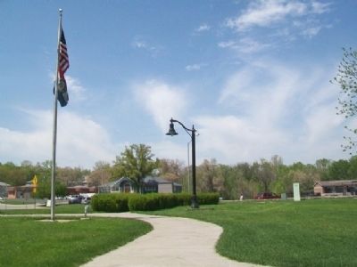
Location. 39° 10.546′ N, 94° 36.905′ W. Marker is in Riverside, Missouri, in Platte County. Marker is at the intersection of NW Vivion Road and NW High Drive, on the left when traveling south on NW Vivion Road. Marker is in Renner Brenner Park, opposite City Hall. Touch for map. Marker is at or near this postal address: 3900 NW Vivion Road, Riverside MO 64150, United States of America. Touch for directions.
Other nearby markers. At least 8 other markers are within 4 miles of this marker, measured as the crow flies. Quindaro Ruins Archaeological Park (approx. 2.9 miles away in Kansas); Quindaro, Kansas (approx. 3 miles away in Kansas); John Brown (approx. 3 miles away in Kansas); Western University (approx. 3 miles away in Kansas); Replica of the Statue of Liberty (approx. 3.1 miles away); War Memorial (approx. 3.1 miles away); a different marker also named War Memorial (approx. 3.1 miles away); Curran Park (approx. 3.2 miles away).
Also see . . . Renner Village Site History. (Submitted on May 8, 2014, by William Fischer, Jr. of Scranton, Pennsylvania.)
Credits. This page was last revised on June 16, 2016. It was originally submitted on May 8, 2014, by William Fischer, Jr. of Scranton, Pennsylvania. This page has been viewed 636 times since then and 26 times this year. Photos: 1, 2, 3. submitted on May 8, 2014, by William Fischer, Jr. of Scranton, Pennsylvania.


