Powhatan Point in Belmont County, Ohio — The American Midwest (Great Lakes)
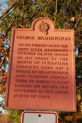
George Washington
Erected by Daughters of the American Revolution.
Topics and series. This historical marker is listed in these topic lists: Colonial Era • Exploration • Waterways & Vessels. In addition, it is included in the Daughters of the American Revolution, the Former U.S. Presidents: #01 George Washington, and the George Washington Slept Here series lists. A significant historical date for this entry is October 24, 1794.
Location. 39° 51.673′ N, 80° 48.244′ W. Marker is in Powhatan Point, Ohio, in Belmont County. Marker can be reached from Railroad Avenue, 0.2 miles south of Mellott Street. Marker is located in park by Captina Creek. Touch for map. Marker is in this post office area: Powhatan Point OH 43942, United States of America. Touch for directions.
Other nearby markers. At least 8 other markers are within 5 miles of this marker, measured as the crow flies. Powhatan Point (approx. 0.2 miles away); The Coal Industry at Powhatan Point / Powhatan Disaster, 1944 (approx. ¼ mile away); Washington's Land (approx. 2½ miles away in West Virginia); a different marker also named Washington's Land (approx. 2.7 miles away in West Virginia); Baker's Station (approx. 4.1 miles away in West Virginia); Zachary Taylor (approx. 4.1 miles away in West Virginia); Thomas H. Trainer (approx. 4½ miles away in West Virginia); Rosby’s Rock (approx. 4.7 miles away in West Virginia). Touch for a list and map of all markers in Powhatan Point.
Credits. This page was last revised on November 29, 2019. It was originally submitted on November 2, 2014, by Mike Wintermantel of Pittsburgh, Pennsylvania. This page has been viewed 1,062 times since then and 51 times this year. Photos: 1, 2, 3. submitted on November 2, 2014, by Mike Wintermantel of Pittsburgh, Pennsylvania.


