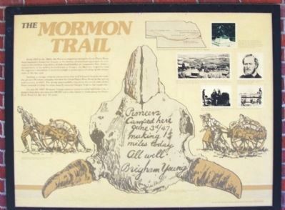
The Mormon Trail
From 1847 to the 1860s, the Mormon migration along the Great Platte River Road marked a distinctive chapter in the history of westward expansion. In contrast to the random migrations of individual families or companies that characterized much of the activity to California or Oregon, the Mormon migration was the organized movement of an entire people to a new place of refuge in the mountains of the far west.
Seeking to escape religious persecution that had followed them in the east, the pioneer Mormon company traveled the Great Platte River Road in the spring and summer of 1847. The group purposefully stayed on the north side of the Platte instead of using the more heavily traveled Oregon Trail on the south side.
On July 24, 1847, Brigham Young's pioneer party founded Salt Lake City, a magnet that drew an estimated 60,000 Latter-day Saints to Utah along the Platte River Road for the next 20 years.
[Illustration captions, from left to right, read]
Some Mormon companies were so poor they pulled crude handcarts the 2,000 miles to Salt Lake City
[On bison skull] Pioneers Camped here June 3d/47 making 15 miles today. All well. Brigham Young
Advance parties of the migration left messages on buffalo skulls for those who would follow.
Several historical sites in Nebraska commemorate the Mormon migration.
Winter
Quarters, near present-day Florence, Nebraska, became the chief outfitting point for the Mormon trek west. During the winter of 1846-1847, more than 600 Mormons died from disease and exposure. The Mormon Cemetery commemorates those who died.Organized in 1830 in upper New York State by the first Mormon prophet leader, Joseph Smith, members of the Church of Jesus Christ of Latter-day Saints later built the city of Nauvoo, Illinois, before their expulsion by mobs in 1845 and 1846.
Brigham Young became the leader of the Mormons after the death of Joseph Smith in 1844. He directed the exodus to Utah.
More than 2,000 Mormons died along the trail. Rebecca Winters' grave, near modern Scottsbluff, is one of the few that has been preserved and marked.
Erected by Nebraska Games and Parks Commission and The Church of Jesus Christ of Latter-Day Saints.
Topics and series. This historical marker is listed in these topic lists: Churches & Religion • Roads & Vehicles • Settlements & Settlers • Waterways & Vessels. In addition, it is included in the Mormon Pioneer Trail series list. A significant historical month for this entry is June 1843.
Location. 40° 49.309′ N, 98° 17.725′ W. Marker is near Grand Island, Nebraska, in Hall County. Marker is on Interstate 80 at milepost 316.5
Other nearby markers. At least 8 other markers are within 6 miles of this marker, measured as the crow flies. Grand Island (a few steps from this marker); The Purple Heart (within shouting distance of this marker); a different marker also named Grand Island (approx. 1.6 miles away); Sinclair Tank Wagon, 1917 (approx. 4˝ miles away); The Pawnee: Prairie Town Builders, Pawnee History (approx. 5.9 miles away); Earth Lodge Design and Construction (approx. 5.9 miles away); Old California Overland Trail (approx. 5.9 miles away); a different marker also named Mormon Trail (approx. 5.9 miles away). Touch for a list and map of all markers in Grand Island.
Also see . . . Mormon Pioneer National Historic Trail. (Submitted on December 17, 2014, by William Fischer, Jr. of Scranton, Pennsylvania.)
Credits. This page was last revised on January 6, 2020. It was originally submitted on December 16, 2014, by William Fischer, Jr. of Scranton, Pennsylvania. This page has been viewed 855 times since then and 24 times this year. Photos: 1, 2, 3. submitted on December 17, 2014, by William Fischer, Jr. of Scranton, Pennsylvania.


