Cosmopolitan Corner
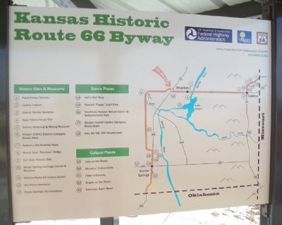
Kansas Historic Route 66 Byway
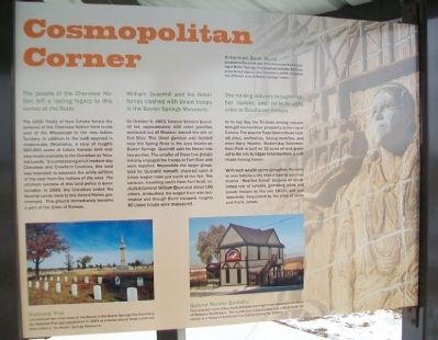
The people of the Cherokee Nation left a lasting legacy to this corner of the State.
The 1836 Treaty of New Echota forced the removal of the Cherokee Nation from lands east of the Mississippi to the new Indian Territory. In addition to the land reserved in modern-day Oklahoma, a strip of roughly 800,000 acres of future Kansas land was also made available to the Cherokee as "Neutral Lands." Encompassing all of modern-day Cherokee and Crawford Counties, this land was intended to separate the white settlers of the east from the Indians of the west. The ultimate success of this land policy is questionable. In 1866, the Cherokee ceded the Neutral Lands back to the United States government. This ground immediately became a part of the State of Kansas.
William Quantrill and his Rebel forces clashed with Union troops in the Baxter Springs Massacre.
On October 6, 1863, Colonel William Quantrill led approximately 400 rebel guerillas westward out of Missouri toward the site of Fort Blair. This Union garrison was located near the Spring River in the area known as Baxter Springs. Quantrill split his forces into two parties. The smaller of these two groups initially engaged the troops at Fort Blair and were repelled. Meanwhile the larger group, lead by Quantrill himself, chanced upon a Union wagon train just north of
the fort. The caravan, travelling south from Fort Scott, included General William [sic - James G.] Blunt and about 100 others. Ambushed, the wagon train was decimated and though Blunt escaped, roughly 90 Union troops were massacred.The mining industry brought robber barons and ne'er-do-wells alike to Southeast Kansas.
In its hey day, the Tri-State mining industry brought tremendous prosperity to the city of Galena. The popular Sapp Opera House hosted plays, orchestras, boxing matches, and even Harry Houdini. Modern-day Schermerhorn Park is built on 22 acres of land granted to the city by Edgar Schermerhorn, a self-made mining tycoon.
With such wealth came corruption. No sooner was Galena a city than it had its own vice district. "Red Hot Street" became an established row of saloons, gambling joints and bawdy houses by the late 1870's and was reportedly frequented by the likes of Jesse and Frank James.
[Photo captions read]
American Bank Mural
Located on the south side of the American Bank building in Baxter Springs, this sculpture includes 450 separate 8-inch square tiles. Installed in 1995, it depicts the different eras of Baxter Springs' history.
National Plot
Located just two miles west of the Byway in the Baxter Springs City Cemetery, the National Plot was established in 1869 as a burial site for those Union soldiers
Galena Murder Bordello
This restored home offers tours and even overnight stays devoted to the story of Madame Staffleback. The murderous madam killed and robbed some 50 clients at a house of prostitution in Galena in the 1890's.
Erected 2014 by USDOT Federal Highway Administration and the State of Kansas.
Topics and series. This historical marker is listed in these topic lists: Industry & Commerce • Native Americans • Settlements & Settlers • War, US Civil. In addition, it is included in the U.S. Route 66 series list. A significant historical month for this entry is October 1984.
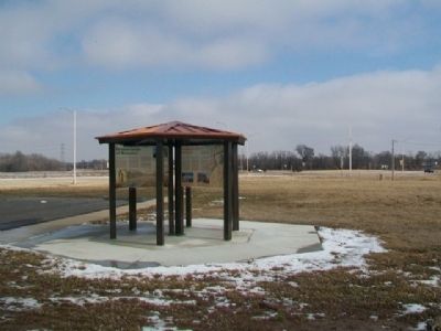
Location. 37° 4.54′ N, 94° 43.039′ W. Marker is in Riverton, Kansas, in Cherokee County. Marker is at the intersection of U.S. 400 and State Highway 66, on the right when traveling south on U.S. 400. Marker kiosk is about 300 feet west of the roundabout. Touch for map. Marker is in this post office area: Riverton KS 66770, United States of America. Touch for directions.
Other nearby markers. At least 8 other markers are within walking distance of this marker. Bridging the American Divide (here, next to this marker); Boom Towns (here, next to this marker); Crossroads of Kansas (here, next to this marker); Land's Legacy (here, next to this marker); Baxter Springs Massacre and Today (a few
Also see . . .
1. Kansas' Historic Route 66 Byway. (Submitted on February 28, 2015, by William Fischer, Jr. of Scranton, Pennsylvania.)
2. Kansas Route 66 Historic Byway on Facebook. (Submitted on February 28, 2015, by William Fischer, Jr. of Scranton, Pennsylvania.)
3. National Historic Route 66 Federation. (Submitted on February 28, 2015, by William Fischer, Jr. of Scranton, Pennsylvania.)
4. Cherokee Nation. (Submitted on February 28, 2015, by William Fischer, Jr. of Scranton, Pennsylvania.)
5. Battle and Massacre of Baxter Springs. (Submitted on February 28, 2015, by William Fischer, Jr. of Scranton, Pennsylvania.)
Credits. This page was last revised on February 19, 2024. It was originally submitted on February 28, 2015, by William Fischer, Jr. of Scranton, Pennsylvania. This page has been viewed 494 times since then and 14 times this year. Photos: 1. submitted on February 28, 2015, by William Fischer, Jr. of Scranton, Pennsylvania. 2, 3. submitted on February 26, 2015, by William Fischer, Jr. of Scranton, Pennsylvania.


