Chantilly in Fairfax County, Virginia — The American South (Mid-Atlantic)
Walney Outbuildings
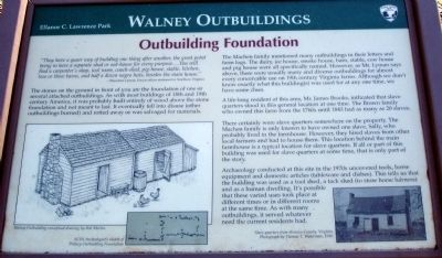
Outbuilding Foundation
— Ellanor C. Lawrence Park —
“They have a queer way of building one thing after another, the great point being to have a separate shed or out-house for every purpose…You will find a carpenter’s shop, tool room, coach-shed, pig-house, stable, kitchen, two or three barns, and half a dozen negro huts, besides the main house.” —Theodore Lyman, Union officer stationed in Northern Virginia
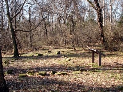
The stones on the ground in front of you are the foundation of one or several attached outbuildings. As with most buildings of the 18th and 19th century America, it was probably built entirely of wood above the stone foundation and not meant to last. It eventually fell into disuse (other outbuildings burned) and rotted away or was salvaged for materials.
The Machen family mentioned many outbuildings in their letters and farm logs. The dairy, ice house, smoke house, barn, stable, cow house and pig house were all specifically named. However, as Mr. Lyman says above, there were usually many and diverse outbuildings for almost every conceivable use on 19th century Virginia farms. Although we don’t know exactly what this building(s) was used for at any one time, we have some clues.
A life-long resident of this area, Mr. James Brooks, indicated that slave quarters stood in this general location at one time. The Brown family who owned this farm from the 1760s until 1843 had as many as 20 slaves.
There certainly were slave quarters somewhere on the property. The Machen family is only known to have owned one slave, Sally, who probably lived in the farmhouse. However, they hired slaves from other local farmers and had to house them. This location behind the main farmhouse is a typical location for slave quarters. If all or part of this building was used for slave quarters at some time, that is only part of the story.
Archaeology conducted at this site in the 1970s uncovered tools, horse equipment and domestic articles (tableware and dishes). This tells us that the building was used as a tool shed, a tack house (to store horse harness) and as a human dwelling. It’s possible that these varied uses took place at different times or in different rooms at the same time. As with many outbuildings, it served whatever need the current residents had.
Erected by Fairfax County Park Authority.
Topics. This historical marker is listed in these topic lists: African Americans • Agriculture • Notable Buildings. A significant historical year for this entry is 1843.
Location. Marker has been reported missing. It was located near 38° 51.615′ N, 77° 25.86′ W.

Photographed By Devry Becker Jones (CC0), May 20, 2022
2. Walney Outbuildings Marker
While the podium remains, the sign is missing.
Other nearby markers. At least 8 other markers are within walking distance of this location. Wipe Your Feet! (within shouting distance of this marker); a different marker also named Walney Outbuildings (within shouting distance of this marker); a different marker also named Walney Outbuildings (within shouting distance of this marker); Walney House (within shouting distance of this marker); The Houses at Walney (about 300 feet away, measured in a direct line); The Walney Dairy (about 400 feet away); a different marker also named The Walney Dairy (about 400 feet away); Walney Barnyard (about 700 feet away). Touch for a list and map of all markers in Chantilly.
More about this marker. The marker features a drawing on the lower left captioned, “Walney Outbuilding conceptual drawing by Rob Martin”, a sketch on the lower left captioned, “FCPA Archeologist's sketch of Walney Outbuilding Foundation”, and a photo on the lower right captioned, “Slave quarters from Henrico County, Virginia. Photograph by Thomas T. Waterman, 1940.”
Also see . . .
1. Ellanor C. Lawrence Park. (Submitted on June 15, 2008.)
2. Theodore Lyman. Biographical Directory of the United States Congress (Submitted on June 15, 2008.)
Credits. This page was last revised on May 21, 2022. It was originally submitted on June 15, 2008. This page has been viewed 1,239 times since then and 14 times this year. Photos: 1. submitted on June 15, 2008. 2. submitted on May 21, 2022, by Devry Becker Jones of Washington, District of Columbia. 3. submitted on June 15, 2008. • Christopher Busta-Peck was the editor who published this page.

