Near Guernsey in Platte County, Wyoming — The American West (Mountains)
The US Army’s Role in Protecting the Oregon Trail is Best Described by the Soldiers
Inscription.
Three plaques, under the same title, describe how the U.S. Army protected immigrants on the Oregon Trail.
Panel 1:
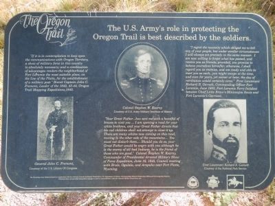
“If it is in contemplation to keep open communications with Oregon Territory, a show of military force in this country is absolutely necessary; and a combination of advantages renders the neighborhood of Fort Laramie the most suitable place, on the line of the Platte, for the establishment of a military post." Brevet Capt. John C. Fremont, leader of the 1842, 43 – 44, Oregon Trail mapping expeditions, 1845.
"Your Great Father… has sent me with a handful of braves to visit you… I am opening a road for your white brethren, and your Great Father directs that his red children shall not attempt to close it up. There are many whites now coming on this road, moving to the other side of the mountains… You must not disturb them… Should you do so, your Great Father would be angry with you although he is the enemy of all bad Indians, he is the friend of those who are good." Col. Stephen W. Kearney, Commander of Presidential directed Military Show of Force Expedition, June 16, 1845, Council meeting with Brule, Ogalala, and Arapaho near Fort Platte, Wyoming.
“I regret the necessity which obliged me to kill any of your people, but under similar circumstances I will always act precisely in the same manner. I am now willing to forget what has passed, and receive you as friends; provided, you promise to behave yourselves hereafter; otherwise, I shall regard you as enemies, and am ready and able to meet you as such… you might escape at the time, and even for years, yet sooner or later, the day of retribution would certainly come." First Lieutenant Richard B Garnett, Commanding Officer Fort Laramie, June 1853, Fort Laramie Ferry Incident between Chief Little Brave’s Miniconjou Sioux and Fort Laramie's Garrison."
Panel 2:
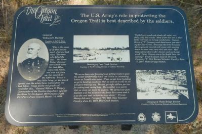
"Who is the cause of all this trouble now? Just one bad man. “The man who killed the cow.” The Great Father does not care about the cow but that fellow was a bad fellow, and was not given up, this caused all the difficulty. It was a very little thing, yet see how it spread over the whole Sioux nation from one bad fellow. I hope all the great people will remember this…" General William S Harney, Commander of the Punitive Expedition Against the Sioux for the August 1854 Grattan fight, Fort Pierre Peace Council March 1-5, 1856.
“We are so busy now building and getting ready to pass the winter comfortably that I can't write as interesting letters as I could other wise. When we get done building we will go to hauling wood and then as soon as it will do we
will go to making hay. We can get eight dollars per ton for cutting and curing hay. The weather is so warm that we sleep outdoors in wagons. We spread our gum blankets and bed ticks over the bows for a cover and it is as dry and cool in there as anywhere.” Private Hervey Johnson, Company "G", 11th Ohio Volunteer Cavalry, June 24, 1864, Deer Creek Station.
“Cold dreary wind and cloudy all night; very chilly, cold and windy. Most of the men are in their tents, overcoats on, to keep comfortable. Capt. Green of "B" Company and detachment just starting for Deer Creek. Snowing like forty thousand devils; ground covered with snow; still pouring down the near way; very cold, wet snow. Quick snowing but clears after dinner; cool northwest wind.” First Sergeant Isaac B Pennock, Company "I", 11th Kansas Volunteer Cavalry, June 17, 1865, Platte Bridge Station."
Panel 3:
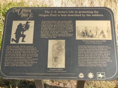
“It was a race of life. Nehring, a private of Company K, 11th Kansas, not understanding the order, dismounted to fight from a deep washout in the road. Cpl. Grimm, looking around, yelled to him in German “to the bridge.” That was the last that was seen of poor Nehring. Camp, lost his horse and then ran for dear life, but within a few rods of safety, was overtaken and tomahawked. Sergeant Hankhammer’s horse was wounded, but carried him
safely to the bridge and then dropped. It was a miracle that any man escaped.” Private Stephen H. Fairfield, Company K, 11th Kansas Volunteer Cavalry, July 26, 1865, Platte Bridge Battle.
“No sir, we don't stop here. We are going into Platte Bridge in spite of all the redskins this side of Hell. … I don't care a damn. You Ohio fellows, decked out in buckskin and fringe think you know too much about this Injun business. We have been South, where fighting is done, and we know how to do it. … You fellows are skeered. We will go on, and if you want to be safe, go on with us. We will cut our way through, or go to Hell a-trying. Forward men!” Commissary Sergeant Amos J Custard, Company H, 11th Kansas Volunteer Cavalry July 26, 1865, Sergeant Custard Army Supply Train Fight.
“Long trains of wagons were winding their way over the plains, the mysterious telegraph wires were stretching across their hunting grounds to the mountains, engineers were surveying a route for a track for the iron horse, and all without saying as much as ‘By your leave’ to the Indians. Knowing that their game would soon be gone, that their hunting grounds taken from them, and that they themselves would soon be without a country, they had resorted to arms to defend their way of life and themselves.” Sergeant Stephen H. Fairfield, Company K, 11th Kansas Volunteer Cavalry, reflecting on the Indian War of 1865, 1903.
Erected by The Wyoming National Guard, in cooperation with the Advisory Council on Historic Preservation, U.S. Department of the Interior, Wyoming State Historic Preservation Office, ad Wyoming State Parks and Historic Sites.
Topics and series. This historical marker is listed in these topic lists: Forts and Castles • Roads & Vehicles • Wars, US Indian. In addition, it is included in the Oregon Trail series list. A significant historical year for this entry is 1842.
Location. 42° 15.378′ N, 104° 44.921′ W. Marker is near Guernsey, Wyoming, in Platte County. Marker can be reached from Lucinda Rollins Road near South Guernsey Road, on the left when traveling west. Touch for map. Marker is in this post office area: Guernsey WY 82214, United States of America. Touch for directions.
Other nearby markers. At least 8 other markers are within walking distance of this marker. Oregon Trail Ruts (within shouting distance of this marker); Forts, Stations, and Camps (within shouting distance of this marker); The United States Army and the Oregon Trail (within shouting distance of this marker); Oregon Trail Ruts State Historic Site (within shouting distance of this marker); a different marker also named Oregon Trail Ruts (within shouting distance of this marker); Encampments in the Guernsey Area (about 400 feet away, measured in a direct line); Grave of Lucindy Rollins (approx. 0.3 miles away); Laramie Peak (approx. one mile away). Touch for a list and map of all markers in Guernsey.
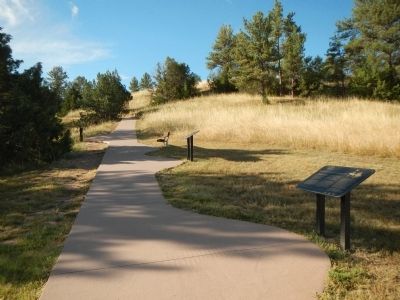
More about this marker. These plaques are in Oregon Trail Ruts State Historic Site on the trail leading from the parking lot to the Oregon Trail Ruts.
Credits. This page was last revised on June 14, 2020. It was originally submitted on July 19, 2015, by Barry Swackhamer of Brentwood, California. This page has been viewed 883 times since then and 31 times this year. Photos: 1, 2, 3, 4. submitted on July 19, 2015, by Barry Swackhamer of Brentwood, California. • Andrew Ruppenstein was the editor who published this page.


