Centro Histórico in Ciudad de México, Mexico — The Valley of Mexico (The Central Highlands)
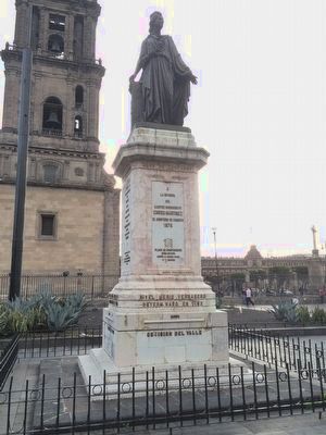
Monument to Enrico Martínez
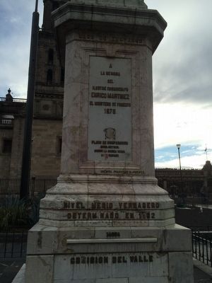
Monumento a Enrico Martínez
— El Nível del Zócalo —
Inscription.
A la Memoria del Ilustre Cosmografo
Henrico Martinez
el Ministerio de Fomento
1878.
Plano de comparación
2268 metros.
Sobre la marea media de Veracruz.
Ing. Civil Francisco M. Jimenez
Nivel medio verdadero determinado en 1862
Yarda
Comision del Valle
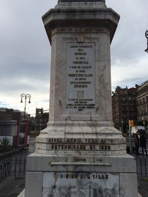
Lago de San Cristobal
Siendo Presidente de la Republica
El Gral. Porfirio Diaz
y Srio. de Fomento
el Gral. Vicente Riva Palacio
se erigio este monumento
Año de 1878
Plano de comparación
2 metros 595
Sobre la banqueta de la esquina N.E. del Palacio Nacional.
1878
Nivel medio verdadero determinado en 1862
Metro
Comision del Valle
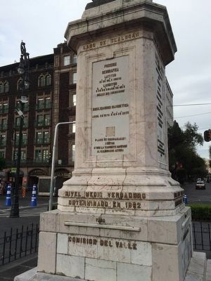
Lago de Tlalocan
Posicion geográfica
Latitud 19˚26’04”, 5 Norte
Longitud
6h36m26s86=99 ˚06’42”6
Oeste de Greenwich
Declinacion magnetica
Abril de 1878. 8 ˚42’52” este
Plano de comparación
Sobre la tangente inferior
al calendario Azteca
Nivel medio verdadero determinado en 1862
Vara
Comision del Valle
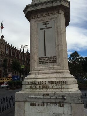
Lago de Xochimilco
Indicador del Lago Texcoco
El aguja marca el nivel actual del lago y la escala de referencia indica los metros bajo el plano de comparación
Nivel medio verdadero determinado en 1862
Metro
Comision del Valle
To the memory of the illustrious cosmographer
Henrico Martínez
The Ministry of Development
1878.
Comparison map
2268 meters above mean sea level at Veracruz.
Civil Engineer Francisco M. Jiménez
Average real level determined in 1862
Yard
Commission of the Valley of the Ciudad de Mexico
Lake San Cristobal
President and General of the Republic
Porfirio Diaz
and Secretary of Development and General
Vicente Riva Palacio
This monument erected in 1878
Comparison map
2 meters 595
Above the NE corner of the National Palace.
1878
Average real level determined in 1862
Meter
Commission of the Valley of the Ciudad de Mexico
Lake of Tlalocan
Geographical position
Latitude 19˚26 '04 ", 5 North
Longitude
6h36m26s86=99 ˚06’42”6
West of Greenwich
Magnetic declination
April 1878 8˚42'52”
Comparison map
From the lower tangent of the Aztec calendar
Average real level determined in 1862
Vara
Commission of the Valley of the Ciudad de Mexico
Lake Xochimilco
Lake Texcoco
indicator
The needle marks the current lake level and the reference scale indicates the meters below the medium level compared
to that determined in 1862
Meter
Commission of the Valley of the Ciudad de Mexico
Erected 1878.
Topics. This historical marker is listed in these topic lists: Hispanic Americans • Industry & Commerce • Science & Medicine. A significant historical month for this entry is April 1878.
Location. 19° 26.036′ N, 99° 8.032′ W. Marker is in Ciudad de México. It is in Centro Histórico. Touch for map. Marker is at or near this postal address: 9 Monte de Piedad, Ciudad de México 06000, Mexico. Touch for directions.
Other nearby markers. At least 8 other markers are within walking distance of this marker. Ruins of an Aztec Pyramid (within shouting distance of this marker); Last Residence of Moctezuma (within shouting distance of this marker); The Main Chapels of the Cathedral of Mexico City (within shouting distance of this marker); Palace of Axayacatl (within shouting distance of this marker); Cuauhtémoc (within shouting distance of this marker); Samir Flores Soberanes (within shouting distance of this marker); Mexico Protests of 1968 (within shouting distance of this marker); Salón Peter Gay (about 90 meters away, measured in a direct line). Touch for a list and map of all markers in Ciudad de México.
Regarding Monument to Enrico Martínez.
Enrico Martínez was probably born in 1550 in Hamburg and worked as a cosmographer and hydraulic engineer for the Spanish government in what is now Mexico. When Hernán Cortés and his soldiers took over Tenochtitlán from the Mexica at the point of the sword, they began a massive building program in order to convert it to their own taste and style. Much of this work involved changing the land use around the capital, which in the time of the Mexica was made up of various large lakes. By modifying the land use in the area, it became more susceptible to flooding. Martínez and other engineers were hired to construct massive canals, tunnels and other hydraulic works. These works were controversial even in Martínez's time, as he was even briefly imprisoned based on allegations of fraud and the high costs of his projects. Martínez died in Mexico City in 1632. Flooding of the capital continued, as the projects never seemed to be able to meet the drainage needs of the “new” capital. Only in modern times have new, massive projects provided a level of protection from floods for Mexico City, although the effects of living on an ancient lakebed continue to be seen with the slow sinking of buildings and the instability of the area during earthquakes.
The monument to Martínez is located on the western side of the Mexico City Metropolitan Cathedral. Its construction began at the initiative
of Vicente Riva Palacio in 1877 and ended in 1881. Originally the pedestal of the sculpture had indicators measuring the water level of Lake Texcoco, the lake that is underneath Mexico City. Currently these indicators are not working, as they were connected to pipes that were at its original location, on the eastern side of the Cathedral. It was designed by architect Francisco Jiménez, and the sculpture built by Miguel Noreña. Locally it is known as “The Level” (El Nível). At one point the oldest bar in the city was located near the original location of the monument and was called The Level Bar (Cantina El Nível). Some historians consider the monument to be the origin of all Mexican road measurements, although there are several versions of this story and it is not clear if this is before or after its relocation. At the base of the monument are the official references for measuring meters, yards and the vara, a local measurement used to measure properties.
Credits. This page was last revised on June 28, 2023. It was originally submitted on November 20, 2015, by J. Makali Bruton of Accra, Ghana. This page has been viewed 733 times since then and 42 times this year. Photos: 1, 2, 3, 4, 5. submitted on November 21, 2015, by J. Makali Bruton of Accra, Ghana.
