Middletown in Frederick County, Virginia — The American South (Mid-Atlantic)
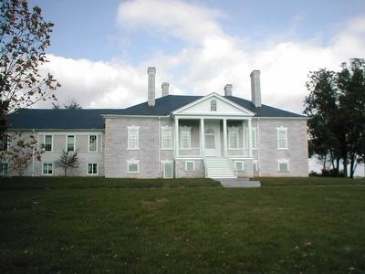
Cedar Creek Battlefield and Belle Grove

Photographed By Devry Becker Jones (CC0), October 23, 2020
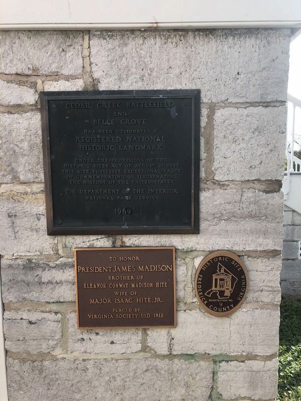
1. Cedar Creek Battlefield and Belle Grove Markers
National Register of Historic Places Nomination Form
Click for more information.
Click for more information.
Cedar Creek Battlefield and Belle Grove has been designated a Registered National Historic Landmark under the jurisdiction of the Historic Sites Act of August 21, 1935. This site possesses exceptional value in commemorating or illustrating the history of the United States.
To honor President James Madison brother of Eleanor Conway Madison Hite wife of Major Isaac Hite, Jr.
Registration No. 9
Erected 1969.
Topics and series. This historical marker is listed in these topic lists: Agriculture • Landmarks • Settlements & Settlers • War, US Civil. In addition, it is included in the Former U.S. Presidents: #04 James Madison, and the National Historic Landmarks series lists. A significant day of the year for for this entry is May 31.
Location. 39° 1.24′ N, 78° 18.224′ W. Marker is in Middletown, Virginia, in Frederick County. Marker is on Belle Grove Road (Virginia Route 727). The marker is located on the exterior wall near the entrance to Belle Grove Plantation mansion. It is a unit of the National Park Service. Touch for map. Marker is at or near this postal address: 336 Belle Grove Rd, Middletown VA 22645, United States of America. Touch for directions.
Other nearby markers. At least 8 other markers are within walking distance of this marker. Old Hall at Belle Grove (within shouting distance of this marker); A Rich Prize (within shouting distance of this marker); In Honor of Joist Hite (1685-1761) (within shouting distance of this marker); The Shenandoah Valley / Battle of Cedar Creek, October 19, 1864 (within shouting distance of this marker); Plantation Slavery (within shouting distance of this marker); Outflanked! (about 400 feet away, measured in a direct line); Enslaved Quarter Site (about 400 feet away); The Enslaved Burial Ground (about 500 feet away). Touch for a list and map of all markers in Middletown.
Also see . . . Welcome to Belle Grove Plantation. Plantation website homepage (Submitted on June 19, 2022, by Larry Gertner of New York, New York.)
Additional commentary.
1. Cedar Creek Battlefield and Belle Grove
“Belle Grove was one of the first mansions built in the Shenandoah Valley; it was completed in 1797 for a sister of James Madison and her husband.
In 1864 it was made into Union General Philip Sheridan's headquarters, and served as a focal point for the Battle of Cedar Creek. Cedar Creek Battlefield, which extends for miles in every direction from Belle Grove, was the site
of the last decisive conflict in the Shenandoah Valley. The Confederate defeat here forced their final retreat from the area, after which General Sheridan devastated it from end to end.” — National Register Form.
— Submitted May 19, 2018, by Allen C. Browne of Silver Spring, Maryland.
Credits. This page was last revised on June 19, 2022. It was originally submitted on February 23, 2016, by Don Morfe of Baltimore, Maryland. This page has been viewed 530 times since then and 28 times this year. Photos: 1. submitted on October 24, 2020, by Devry Becker Jones of Washington, District of Columbia. 2. submitted on February 23, 2016, by Don Morfe of Baltimore, Maryland. • Kevin W. was the editor who published this page.
